

SDEIS Public Hearing Online Presentation
The information below can be translated to your preferred language by clicking the Select Language button at the top right of this page.
Welcome to the online presentation of the Public Hearing for the I-495 & I-270 Managed Lanes Study Supplemental Draft Environmental Impact Statement (SDEIS).
This online presentation provides a detailed overview of the I-495 & I-270 Managed Lanes Study, in compliance with the National Environmental Policy Act (NEPA). For ease of use, the presentation is broken down into eight sections. Each of these sections addresses 1-4 questions, shown below.
Study Overview
-
What is the purpose of the SDEIS?
-
What is the purpose of the comment period and public hearing?
-
What are the limits of the improvements?
-
What is the Study’s Purpose And Need?
Alternatives
-
What is the Preferred Alternative?
-
What transit components are included in the Preferred Alternative?
-
How will the Preferred Alternative enhance biking and walking?
-
Where are the proposed interchanges & managed lanes access locations?
Traffic Analyses
-
Why is this Study needed?
-
How has the COVID-19 pandemic impacted the Study?
-
Was the traffic analysis updated for the SDEIS?
-
What traffic benefits would be expected from the Preferred Alternative?
Environmental Review
-
What are the environmental effects of the Preferred Alternative?
-
What avoidance and minimization efforts have been considered for significant natural, community and historic resources?
-
Why was the Draft Section 4(f) Evaluation updated?
Potential Property Needs
-
Reduction of potential property needs with the Preferred Alternative
- What happens if my property is directly impacted?
Noise
-
What is the proposed noise mitigation?
Public, Stakeholder & Agency Engagement
-
What stakeholder and agency engagement has occurred since the DEIS?
-
How can I review the SDEIS?
-
How do I comment on the SDEIS?
Public-Private Partnership (P3) Program
-
What is a P3?
-
A P3 is not
-
What is the status of the Phase 1 solicitation process and P3 agreement?
SDEIS Online Presentation
- Study Overview
- Alternatives
- Traffic Analyses
- Environmental Review
- Potential Property Needs
- Noise
- Public, Stakeholder, & Agency Engagement
- Public-Private Partnership (P3) Program
What is the purpose of the SDEIS?
This Supplemental Draft Environmental Impact Statement (SDEIS) has been prepared to consider new information relative to the Preferred Alternative: Alternative 9-Phase 1 South: American Legion Bridge I-270 to I-370. Building off the analysis in the existing DEIS, the SDEIS discloses new information relevant to the Preferred Alternative while referencing the DEIS for information that remains valid.
What is the purpose of the comment period and public hearing?
To provide the public an opportunity to comment on the Preferred Alternative and associated impacts as presented in the SDEIS. Comments will be accepted during the 45-day comment period starting on Friday, October 1, through 11:59 PM on Monday, November 15, 2021. The public can provide verbal testimony at one virtual public hearing through two sessions on Monday, November 1, 2021.
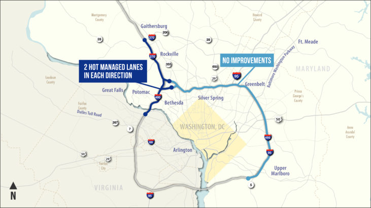
What are the limits of the improvements?
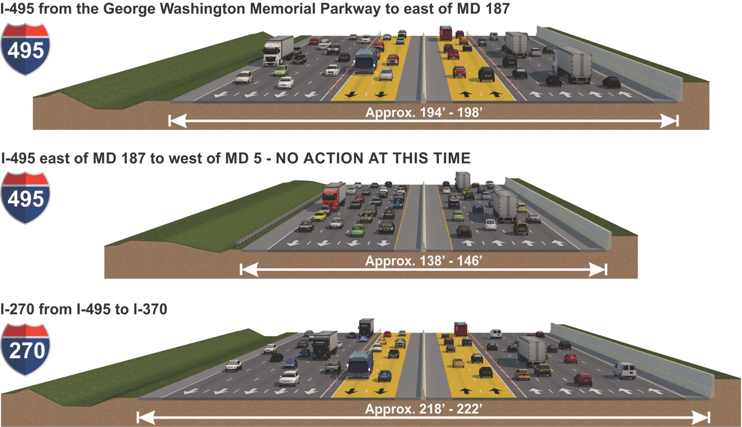
The limits of the Study from the DEIS includes 48 miles along I-495 and I-270. The Study limits on I-495 begin south of the George Washington Memorial Parkway in Virginia, across the American Legion Bridge, to west of MD 5 and on I-270 from I-495 to north of I-370 in Montgomery and Prince George’s counties, Maryland.
While the limits of the Study remain unchanged, the limits of the build improvements associated with the Preferred Alternative occur only within the limits of Phase 1 South on I-495 from south of the George Washington Memorial Parkway to east of MD 187 and on I-270 from I-495 to north of I-370, including the I-270 west and east spurs.
What is the Study's purpose and need?
The Purpose and Need Statement remains the same as presented in the DEIS, Chapter 1 and in DEIS, Appendix A.
Purpose Develop a travel demand management solution(s) that addresses congestion, improves trip reliability on I-495 and I-270 within the study limits and enhances existing and planned multimodal mobility and connectivity.Needs
- Accommodate Existing Traffic and Long-Term Traffic Growth
- Enhance Trip Reliability
- Provide Additional Roadway Travel Choices
- Accommodate Homeland Security
- Improve Movement of Goods and Services
-
Financial Viability
-
Environmental Responsibility
The Purpose and Need remains valid with the Preferred Alternative. MDOT SHA and FHWA identifying Alternative 9-Phase 1 South: American Legion Bridge I-270 to I-370 as the Preferred Alternative does not alter the Study’s Purpose and Need. The overall need for improvements in the study area remains valid, regardless of the build alternatives evaluated and any potential change to the limits of construction for a Preferred Alternative.
What is the Preferred Alternative?
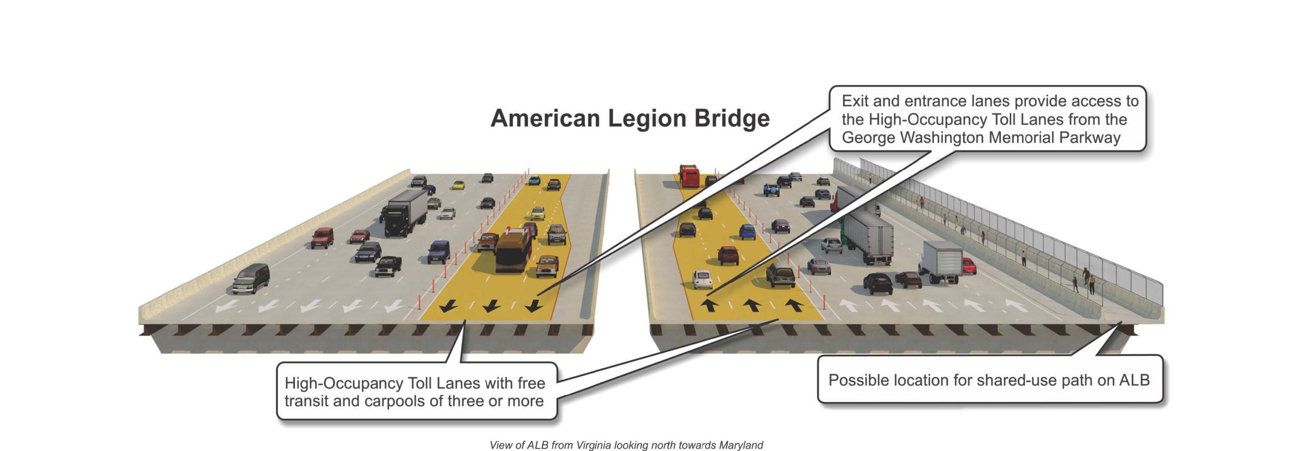
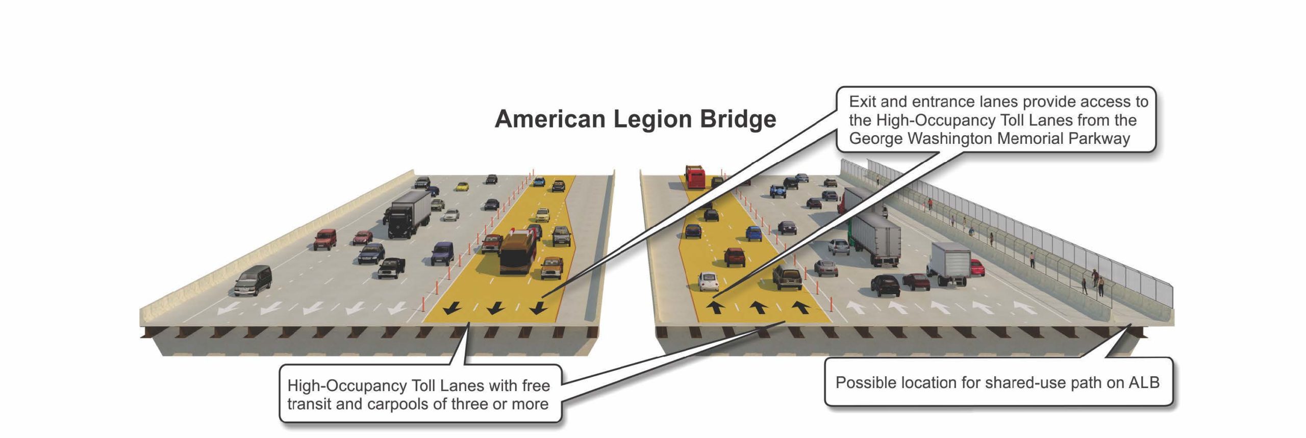
The Preferred Alternative includes a two-lane, High-Occupancy Toll (HOT) managed lanes network on I-495 and I-270 within the limits of Phase 1 South only on I-495 from south of the George Washington Memorial Parkway to east of MD 187 and on I-270 from I-495 to north of I-370, including the I-270 west and east spurs. No action nor improvements are included on I-495 east of the I-270 east spur to MD 5 at this time.
On I-270, the Preferred Alternative consists of converting the one existing High Occupancy Vehicle (HOV) lane in each direction to a HOT managed lane and adding one new HOT managed lane in each direction from I-495 to north of I-370 and on the I-270 East and West Spurs. Along I-270, the existing collector-distributor (C-D) lanes from Montrose Road to I-370 would be removed as part of the proposed improvements.
The HOT managed lanes would be separated from the general purpose lanes using pylons placed within a buffer. Transit buses and HOV 3+ vehicles would be permitted to use the HOT managed lanes toll-free.
What transit components are included in the Preferred Alternative?
- Allowing toll free use of the HOT managed lanes for bus transit to provide an increase in speed of travel, assurance of a reliable trip, and connection to local bus service/systems on arterials that directly connect to urban and suburban activity and economic centers.
-
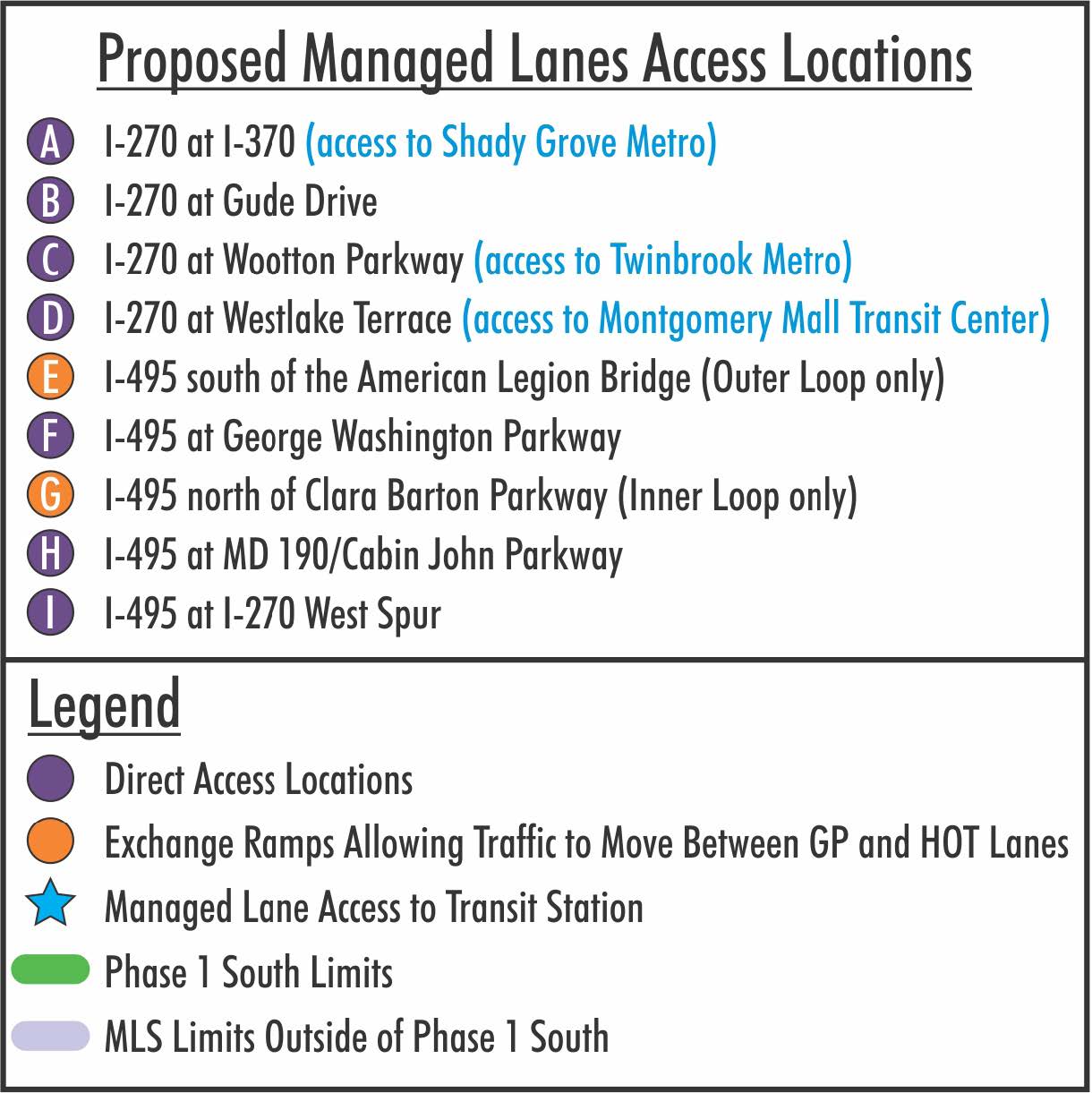
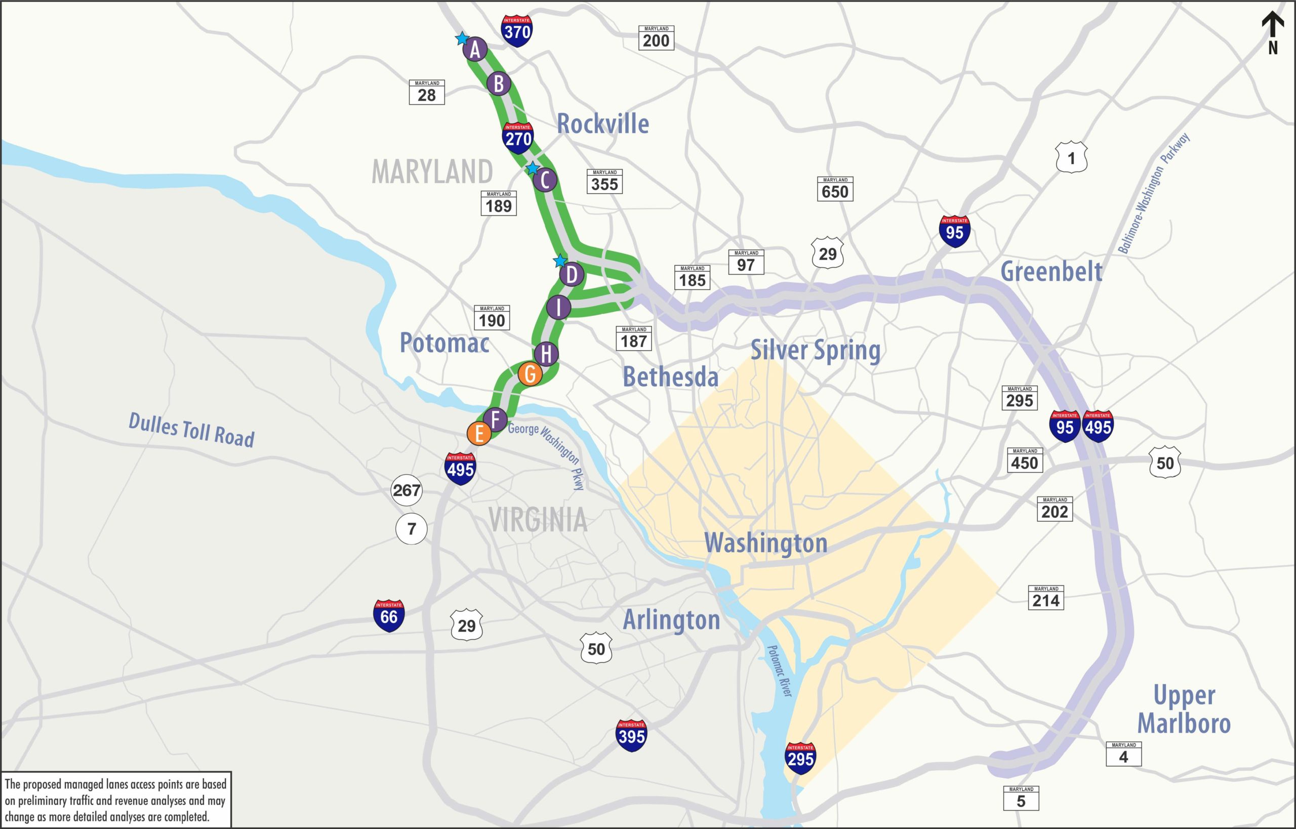
Accommodating direct and indirect connections from the proposed HOT managed lanes to existing transit stations and planned Transit Oriented Development at the Shady Grove Metro (I-370), Twinbrook Metro (Wootton Parkway), Montgomery Mall Transit Center (Westlake Terrace), and Medical Center Metro (MD 187).
-
Additionally, regional transit improvements to enhance existing and planned transit and support new opportunities for regional transit service have been committed to as part of the Preferred Alternative and include:

California Transit -
Constructing new bus bays at WMATA Shady Grove Metrorail Station
-
Increasing parking capacity at the Westfield Montgomery Mall Park and Ride
-
How will the Preferred Alternative enhance biking and walking?
MDOT and the Virginia Department of Transportation have agreed to reconstruct the American Legion Bridge (ALB) with a new pedestrian and bicycle shared-use path to provide multi-modal connectivity across the Potomac River, anticipated along the east side of the ALB. The shared-use path would connect to the planned Fairfax County trail system and the Montgomery County master plan trail system at MacArthur Boulevard. An existing connection from the MacArthur Boulevard sidepath to the C&O Canal towpath exists just outside of the Study Area, supporting regional connectivity.
Other enhancements to pedestrian and bicycle connections include but are not limited to:
- Constructing new sidepaths across MD 190 over I-495
- Widening the existing sidepath along Seven Locks Road under I-495 (Cabin John Trail)
- Constructing new sidewalk along the west side of Seven Locks Road under I-495 to connect First Agape AME Zion Church (Gibson Grove Church) and Morningstar Tabernacle No. 88 Moses Hall and Cemetery
- Lengthening the I-270 bridge over Tuckerman Lane to accommodate future pedestrian/bicycle facilities along Tuckerman Lane
Is the replacement of the American Legion Bridge part of the Managed Lanes Study?
Yes, the Preferred Alternative includes the full replacement of the American Legion Bridge (ALB) with a new, wider bridge (not widening of the existing bridge). The existing bridge is nearly 60 years old and would need to be replaced sometime over the next decade regardless of this Study. The new bridge would be constructed in phases to maintain the same number of existing lanes at all times, and therefore the old bridge would be replaced in the same existing location.
The ALB will be designed to accommodate one or more future projects to achieve the full implementation of a transit line across the ALB. These future transit options can be implemented with minimal impacts to capacity and operations of the managed lanes and general purpose lanes constructed by Phase 1 South of the P3 Program. Future transit would be accommodated by designing the new ALB structures to allow for future superstructure modifications and additional foundation and substructure capacity capable of supporting a new transit line.
Where are the proposed interchanges & managed lanes access locations?

Why is this Study needed?
To address existing and future traffic congestion:
- Traffic congestion limits economic growth opportunities
- Traffic congestion diminishes the quality of life for Marylanders
- Severe congestion averages 10 hours on I-495 and 7 hours on I-270 each weekday
How has the COVID-19 pandemic impacted the Study?
The COVID-19 global pandemic has had a profound impact on the daily routines of people across the world, affecting the way residents and commuters in the National Capital Region work, travel, and spend their free time. These changes have altered traffic demand, transit use, and traffic volumes on all roadways in Maryland, the District of Columbia, and Virginia, including I-495 and I-270.

MDOT SHA has been closely monitoring the changes in traffic patterns throughout the pandemic. Traffic volumes have continued to recover following the vaccine roll-out and the gradual reopening of businesses and schools in the spring and summer of 2021. Statewide, weekly traffic volumes were down 7% in August 2021 compared to August 2019. MDOT SHA will continue to monitor changes into the fall and winter and will conduct a sensitivity analysis to evaluate potential long-term impacts, confirm the need for the project, and verify that the preferred alternative would provide benefits if future demand is less than projected as part of the COVID-19 Travel Analysis and Monitoring Plan for the Study.
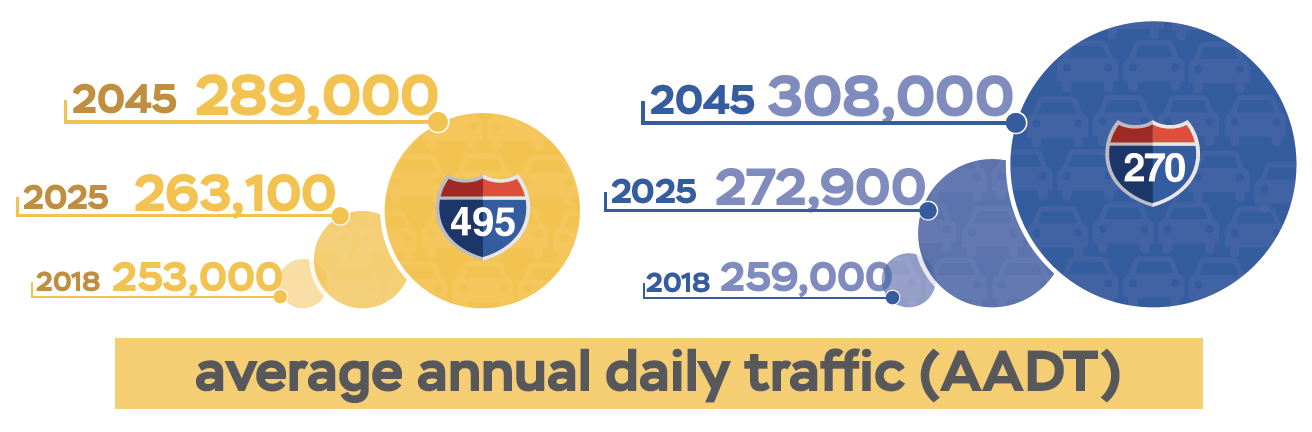
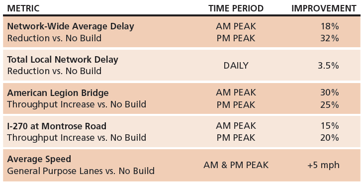
Was the traffic analysis updated for the SDEIS?
The traffic analysis was updated from a design year of 2040 to a design year of 2045 for the No Build and Preferred Alternative using the regionally approved traffic model from the Metropolitan Planning Organization.
The Preferred Alternative, Alternative 9-Phase 1 South: American Legion Bridge I-270 to I-370, was evaluated and compared to the No Build condition using the updated 2045 forecasts for several key operational metrics, including: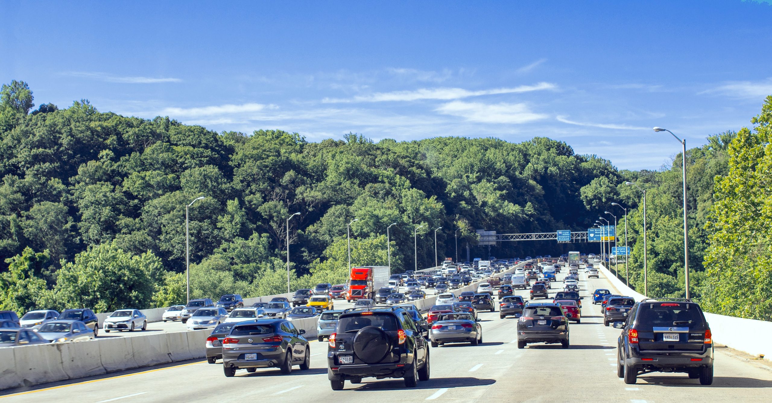
- Speed
- Delay
- Travel time
- Level of service
- Throughput
- The effect on the local network
These metrics are the same metrics used in the DEIS to evaluate and compare the alternatives.
What traffic benefits would be expected from the Preferred Alternative?
The Preferred Alternative will significantly increase person throughput across the American Legion Bridge and on the southern section of I-270 while reducing congestion.
Compared to the No Build Alternative, the Preferred Alternative will:
- Increase speeds
- Improve trip reliability
- Reduce travel times and delays
What are the environmental effects of the Preferred Alternative?
The environmental consequences presented in Chapter 4 are described for the Preferred Alternative. Permanent (or long-term) and temporary (or short-term) construction-related effects of the Preferred Alternative are quantified and presented in this SDEIS. The summary of environmental effects of the Preferred Alternative are presented below.
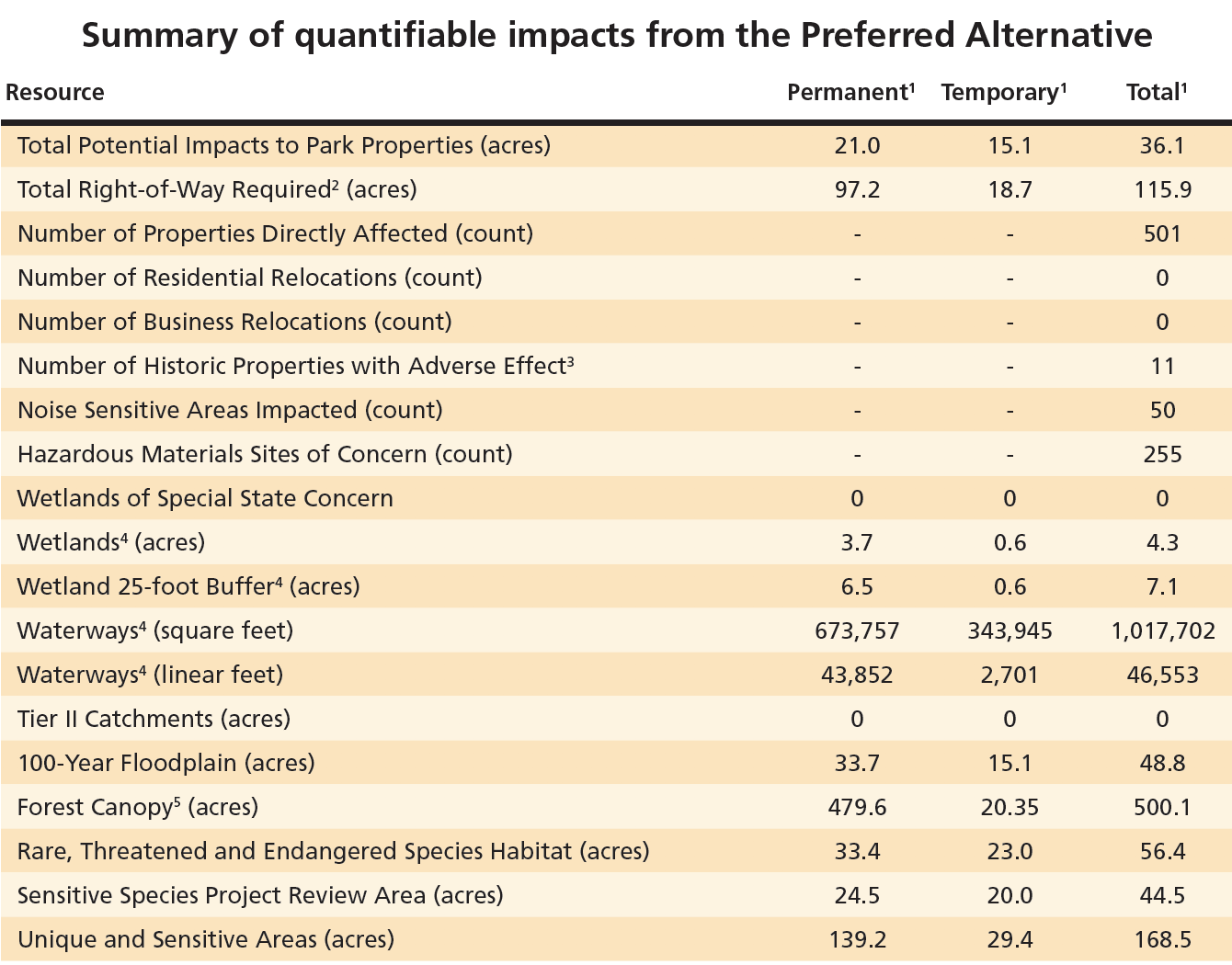
1 All values are rounded to the tenths place
2 The right-of-way is based on State records research and supplemented with county right-of-way, as necessary
3 Refer to Chapter 4, Section 4.7 for additional details on the effects to historic properties
4 Refer to Table 4-25, Section 4.12 for additional details on the impacts to wetlands and waterways
5 Temporary forest canopy impacts are cleared forest in areas that will not be permanently acquired or altered by roadway construction. Replanting will occur in these areas. Impacts will be avoided and minimized, and replanting will be maximized within the corridor as determined in final design.
What avoidance and minimization efforts have been considered for significant natural, community and historic resources?
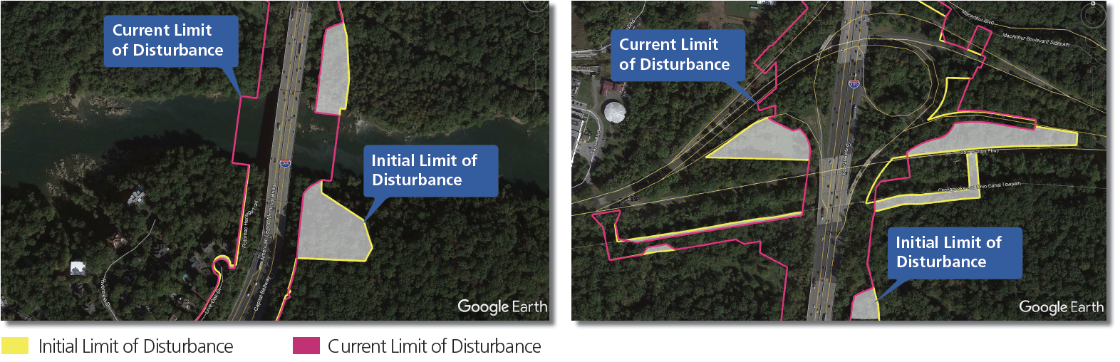
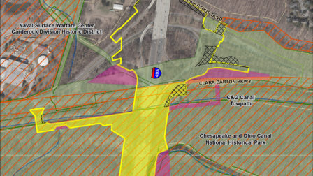
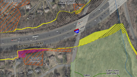
Since the publication of the DEIS, avoidance and minimization of historic properties, park lands, wetlands, wetland buffers, waterways, forests, and the Federal Emergency Management Agency’s 100- year floodplain have advanced through coordination with the regulatory and resource agencies. The Preferred Alternative with the Phase 1 South limits avoids over 100 acres of parkland and hundreds of wetland and stream features compared to the DEIS Build Alternative 9.
The impacts associated with the Preferred Alternative were avoided and minimized to the greatest extent practicable in all areas at this preliminary stage of the Study, and avoidance and minimization techniques were specifically refined in some areas of sensitive or recreationally valuable resources, such as the NPS park properties around the American Legion Bridge. Final avoidance and minimization efforts and mitigation for unavoidable impacts will be documented in the FEIS.
Why was the Draft Section 4(f) Evaluation updated?
Since the publication of the DEIS and Draft Section 4(f) Evaluation in July 2020, the Preferred Alternative has been identified as Alternative 9–Phase 1 South American Legion Bridge I-270 to I-370, which includes the same improvements proposed as part of Alternative 9 in the DEIS and Draft Section 4(f) Evaluation but limited to the Phase 1 South limits only. The Preferred Alternative was identified based on further coordination with agencies, including the Officials with Jurisdiction (OWJs) to avoid and minimize impacts to significant Section 4(f) properties.
The Preferred Alternative would avoid the use of 38 Section 4(f) properties that were previously reported as Section 4(f) uses in the DEIS and Draft Section 4(f) Evaluation totaling approximately 105 acres. The Preferred Alternative would require use a total of 39.1 acres of 21 Section 4(f) properties (including temporary and permanent), compared to a total of 146.8 acres for the DEIS Build Alternative 9.
Conceptual mitigation for Section 4(f) impacts has been identified, but coordination with the OWJs for the Section 4(f) properties is still ongoing. The Final Section 4(f) Evaluation will also include finalization of the analysis to demonstrate all possible planning to minimize harm, and finalization of the Least Overall Harm Analysis, and final mitigation commitments.
Proposed property needs
What determines if my property is needed?
- A variety of elements contribute to the need for additional property rights outside of MDOT SHA’s property. These elements include roadway construction, grading, clearing, landscaping, stormwater management, and noise barrier replacement/construction. Adjacent property rights would be needed in areas where MDOT SHA right-of-way is limited and where these elements cannot be located elsewhere.
What are my rights related to property acquisition?
- MDOT SHA complies with State and Federal laws to determine “just” compensation for impacts to your property.
- Just compensation is based on the fair market value of the property and includes all elements that may be appropriate in determining value.
- For full details on the acquisition process, please refer to the MDOT SHA Your Land and Your Highways: Your Rights and Benefits Guide.
How will I know that my property is needed?
- MDOT SHA will advise you well in advance of actual negotiations. A letter will be mailed to you explaining that your property will be needed.
What will I be paid for my property if it is needed?
- MDOT SHA will offer fair market value of your property, which will include just compensation for the property needed. Relocation assistance is a separate benefit that is provided, if eligible.
Will I be compensated for indirect impacts, such as noise?
- MDOT SHA can only provide compensation as part of the property acquisition process. However, we will work with you to address concerns related to any possible impacts on your property.
Reduction of potential property needs with the Preferred Alternative
The Preferred Alternative:
Avoids all residential and business displacements Currently impacts 501 properties within the Preferred Alternative limits of disturbance, resulting in 891–1,017 properties avoided from the DEIS Build Alternatives Results in property impacts due to: Roadway widening to construct additional travel lanes- Reconfiguration of interchange ramps
- Reconstruction of significant bridges and other structures
- Augmentation and extension of culverts
- Replacement or extension of existing noise barriers
- Construction of new noise barriers
- Utility relocation that cannot be accommodated within existing highway right-of-way
- Acquiring strips of land, or strip takes, from undeveloped areas or areas of trees and landscaping in yards that back up to I-495 or I-270
- Acquisition of larger areas to accommodate stormwater management facilities or drainage improvements
What happens if my property is directly impacted?
Timeline of the Acquisition ProcessSPRING 2022: Complete National Environmental Policy Act (NEPA) Study
IDENTIFICATION: During final design, MDOT SHA determines if property is needed to construct the project (No earlier than late 2021)
FORMAL NOTIFICATION: Property owner will receive a notification letter
PRE-ACQUISITION: MDOT SHA determines the property rights that may be needed for the new improvement and the impacts on your remaining property
APPRAISAL: A qualified real estate appraiser will appraise your property and MDOT SHA will set the just compensation to be offered
NEGOTIATIONS: A real property specialist will contact you to set up an appointment to discuss the acquisition and the offer
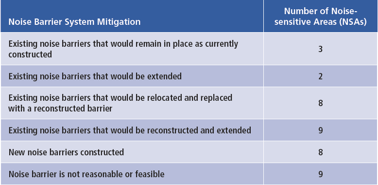
What is the proposed noise mitigation?
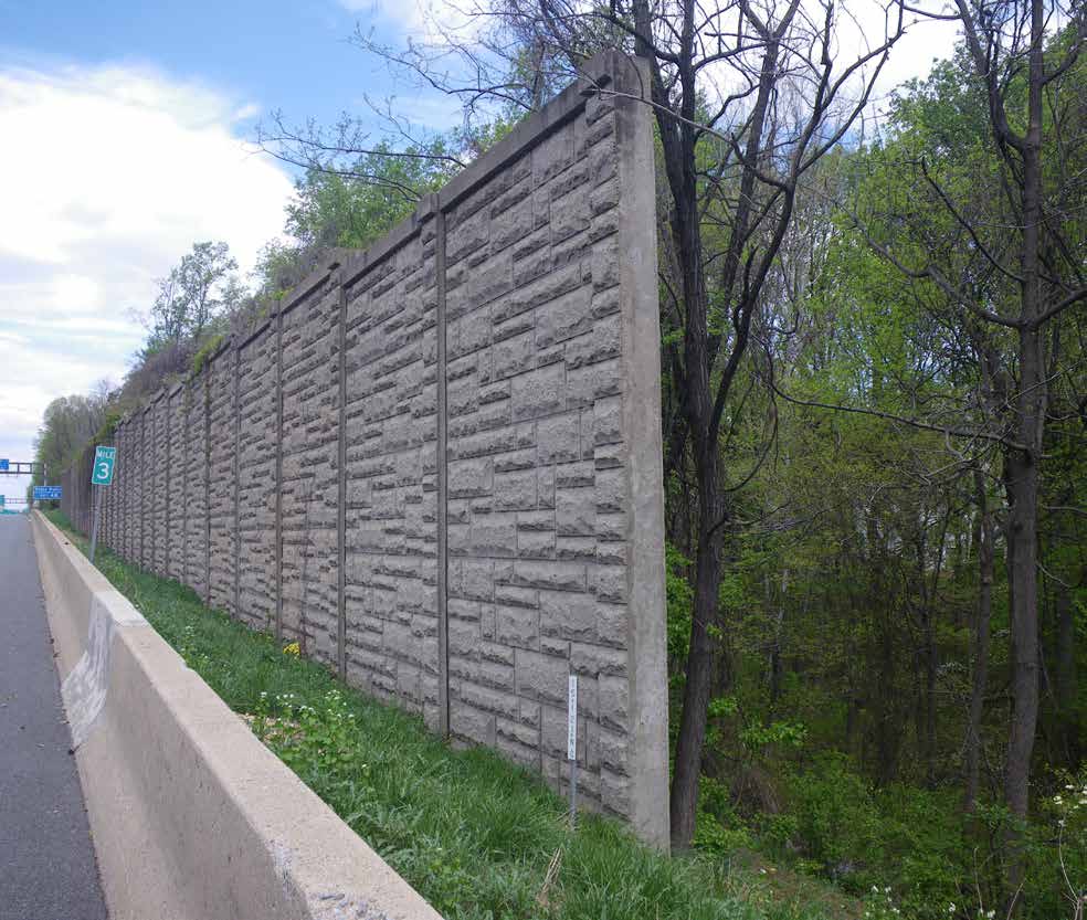
The results of the updated noise analysis for the Preferred Alternative are presented in the SDEIS. A summary of the noise barrier mitigation is listed below. The proposed noise barrier locations can be seen as a layer on the interactive GIS mapping and in the environmental resource mapping in Appendix D of the SDEIS. Both can be located on the Op Lanes Maryland website at OpLanesMD.com.
What stakeholder and agency engagement has occurred since the DEIS?
Engagement with stakeholders and the agencies continued to occur after the DEIS was published in July 2020.
The focus of this engagement was to:
Better understand comments received on the DEIS
Provide Study related updates, and seek feedback on a host of topics, including:
- Effects of covid-19 on traffic
- Transit opportunities
- Alternatives design
- Managed lanes access
- Bicycle and pedestrian improvements
- Economic benefits
- Environmental concerns
- 3 Environmental Justice Working Group Meetings
- 1 Transit Working Group Meetings
- 4 Regional Economic Working Group Meetings
- 54 Agency and Stakeholder Coordination Meetings (public)
- 81 Agency and Stakeholder Coordination Meetings (government)
- 3 Interagency Working Group Meetings
- 65 Natural Resource Agency Coordination Meetings
- 8 Section 106 Consultation Meetings
- 4 Community Pop-up Events
- 42 Elected Official Meetings
How can I review the SDEIS?
The SDEIS and its supporting information is available on the Op Lanes Maryland website at OpLanesMD.com/SDEIS. Hard copies will be available for review starting on Friday, October 1 through November 15, 2021.
| LOCATION | ADDRESS | VIEWING HOURS |
| MONTGOMERY COUNTY | ||
| Gaithersburg Library | 18330 Montgomery Village Avenue, Gaithersburg, MD 20879 | Mon, Wed, Fri & Sat: 10 AM - 6 PM Tue & Thu: 12 - 8 PM Sun: Closed * The Rockville and Greenbelt libraries will have hard copies of the SDEIS and Technical Reports available. All other libraries will have the technical reports on USB flash drives. |
| Quince Orchard Library | 15831 Quince Orchard Road, Gaithersburg, MD 20878 | |
| Rockville Memorial Library* | 21 Maryland Avenue, Rockville, MD 20850 | |
| Potomac Library | 10101 Glenolden Drive, Potomac, MD 20854 | |
| Davis Library | 6400 Democracy Boulevard, Bethesda, MD 20817 | |
| Kensington Park Library | 4201 Knowles Avenue, Kensington, MD 20895 | |
| Chevy Chase Library | 8005 Connecticut Avenue, Chevy Chase, MD 20815 | |
| Silver Spring Library | 900 Wayne Avenue, Silver Spring, MD 20910 | |
| White Oak Library | 11701 New Hampshire Avenue, Silver Spring, MD 20904 | |
| PRINCE GEORGE’S COUNTY | ||
| Beltsville Branch | 4319 Sellman Road, Beltsville, MD 20705 | Mon, Tue, Thu, & Fri: 10 AM - 6 PM Wed: 12 - 8 PM - Sat: 10 AM - 5 PM Sun: Closed |
| Greenbelt Branch | 11 Crescent Road, Greenbelt, MD 20770 | |
| New Carrollton Branch Library | 7414 Riverdale Road, New Carrollton, MD 20784 | |
| Glenarden Branch Library | 8724 Glenarden Parkway, Glenarden, MD 20706 | |
| Largo-Kettering Branch Library | 9601 Capital Lane, Upper Marlboro, MD 20772 | |
| Spauldings Branch Library | 5811 Old Silver Hill Road, District Heights, MD 20747 | |
| Oxon Hill Branch | 6200 Oxon Hill Road, Oxon Hill, MD 20745 | |
| FAIRFAX COUNTY | ||
| Dolly Madison Library | 1244 Oak Ridge Avenue, McLean, VA 22101 | Mon & Tue: 10 AM – 9 PM • Wed, Thu, Fri & Sat: 10 AM – 6 PM • Sun: Closed |
| WASHINGTON DC | ||
| Juanita E. Thornton/Shepherd Park Neighborhood Library | 7420 Georgia Avenue NW, Washington, DC 20012 | Mon, Tue, Wed, Fri & Sat: 10 AM - 6 PM Thu: 12 - 8 PM - Sun: Closed |
How do I comment on the SDEIS?
The SDEIS will be available so that interested citizens, elected officials, government agencies, businesses, and other stakeholders can comment on the Preferred Alternative and associated impacts as presented in the SDEIS during the 45-day 60-day comment period starting on Friday, October 1, through 11:59 PM on Monday, Monday, November 15, 2021 Wednesday, November 30, 2021. MDOT SHA and FHWA will consider comments received and will respond to substantive comments on both the SDEIS and DEIS in the FEIS.
The public can provide verbal testimony at one virtual public hearing through two sessions on Monday, November 1, 2021. Register at OpLanesMD.com/SDEIS or by dialing 855-432-1483.
Ways To Comment on the SDEIS
- Provide verbal testimony at virtual public hearing sessions
- Provide verbal testimony via voicemail (855-432-1483) during virtual public hearing sessions, or throughout the 45-day 60-day comment period
- Submit an electronic comment form on OpLanesMD.com/SDEIS
- Send an email to OpLanesMLS@mdot.maryland.gov
- Send a written letter about the SDEIS to:
Jeffrey T. Folden, P.E., DBIA Director, I-495 & I-270 P3 Office Maryland Department of Transportation State Highway Administration 707 North Calvert Street Mail Stop P-601 Baltimore, MD 21202
The Maryland Relay Service can assist teletype users at 7-1-1. Individuals requiring assistance to participate, such as an interpreter for hearing/speech difficulties or assistance with the English language, should contact the Program toll-free number at 833-858-5960 by October 22, 2021.
ALL COMMENTS received, regardless of method of submission, will be given EQUAL CONSIDERATION.
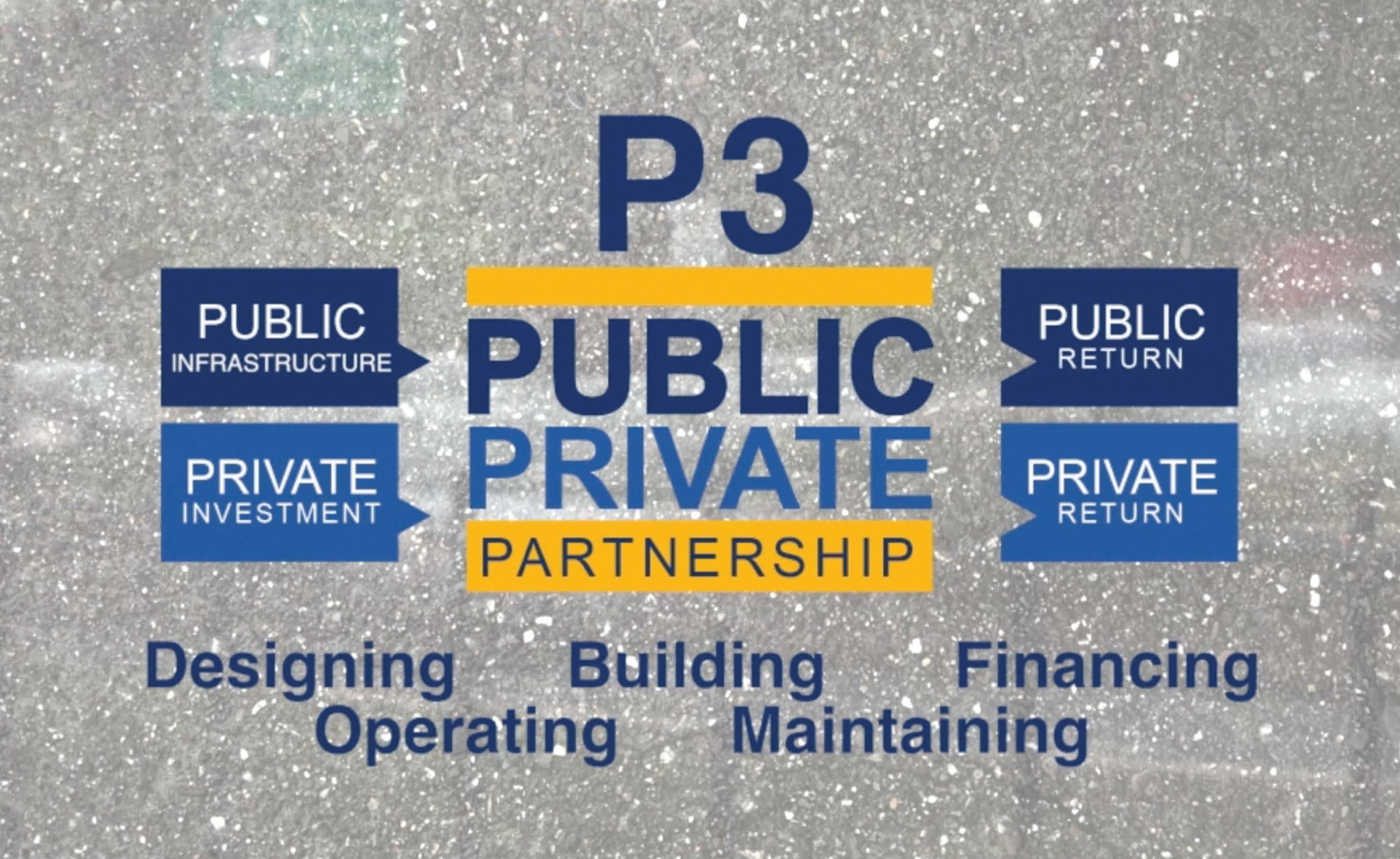
What is a P3?
A Public-Private Partnership (P3) is an alternative model for delivery of a capital project. A P3 is a partnership between the public or governmental sector with private entities. The P3s seek to harness private sector expertise, innovation, and financing to deliver public infrastructure for the benefit of the public owner and users of the infrastructure.P3s seek to successfully leverage the respective strengths of the public and private sectors to deliver large, complex infrastructure projects in a cost effective and timely fashion. Functions under a P3 agreement may include designing, building, financing, operating, and maintaining a transportation facility.
BENEFITS OF A P3 Projects delivered faster: P3 projects can move forward when the public owner does not have available funding.Provides equity and financing: Without a P3, proposed improvements of this magnitude would take decades and would use Maryland’s entire transportation budget.
Operations and maintenance: The P3 developer operates the facility and maintains it over the term of the agreement at a more economical cost.
Transfer of risks: The public owner and the private partner share the risks based on who can best manage each risk to provide the best value to the public owner, such as revenue risk, design and construction risks, long-term operations and maintenance risks.
A P3 is not...
A Funding Source: Projects require user fees or tax dollars regardless if a P3 is used.
Privatization: The private partner does not obtain any ownership—the State is still the owner.
Transfer of State Responsibility: The State retains the ultimate responsibility to ensure the facility meets its intended public need. The private sector also cannot have decision making in the environmental process as it is a government function.
What is the status of the Phase 1 solicitation process and P3 agreement?
Phase 1 Solicitation: Select developer for Phase 1: New American Legion Bridge I-270 to I-70 Traffic Relief Plan*WE ARE HERE* Predevelopment Work: Having received Board of Public Works (BPW) approval, Phase 1 developer begins collaborative predevelopment work to advance the Preferred Alternative for the MLS within Phase 1 South
Committed Selection Proposals: At conclusion of the predevelopment work and NEPA process, the phase developer will offer a committed price and schedule for delivery of the first section
Section Development: BPW will be asked to consider and approve the committed section proposal to deliver the first section