

I-495 & I-270 Public Hearing Online Presentation
The information below can be translated to your preferred language by clicking the Select Language button at the top right of this page.
Welcome to the online presentation of the Joint Public Hearing for the I-495 & I-270 Managed Lanes Study Draft Environmental Impact Statement (DEIS) and Draft Section 4(f) Evaluation, which also includes the Joint Permit Application (JPA). This is a joint hearing held by the Federal Highway Administration (FHWA) and Maryland Department of Transportation State Highway Administration (MDOT SHA) as the lead agencies, as well as the United States Army Corps of Engineers (USACE) and the Maryland Department of the Environment (MDE).
This online presentation provides a detailed overview of the I-495 & I-270 Managed Lanes Study, in compliance with the National Environmental Policy Act (NEPA). For ease of use, the presentation is broken down into nine stations. Each of these stations addresses 1-4 questions, shown below.
Station 1 - Study Overview
- What is the purpose of the Joint Public Hearing?
- What is the NEPA process?
- Why is this Study needed?
- What is the Purpose & Need?
Station 2 - Alternatives
- What are managed lanes?
- What Alternatives are considered in the DEIS?
- How will transit, biking, and walking be enhanced?
- What is congestion pricing?
Station 3 - Traffic Analyses
- How do the Build Alternatives reduce congestion and delay?
- How will traffic operations move more people through the study corridors?
Station 4 - Environmental Review
- What are the environmental effects?
- What are the Study needs, and how are you reducing the needs?
- What is the potential mitigation?
- What avoidance and minimization has been considered?
Station 5 - Potential Property Needs
- What happens if my property is needed?
Station 6 - Noise
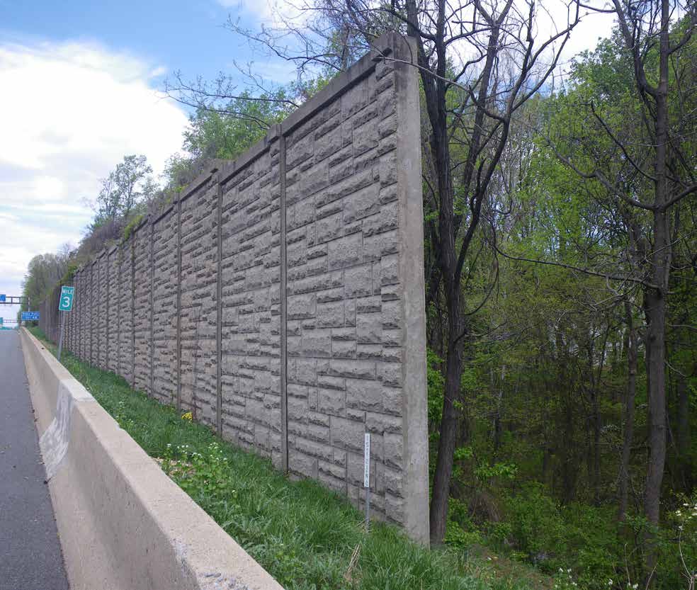
- What happens if my property is impacted by noise?
Station 7 - Joint Permit Application
- What is the JPA process?
Station 8 - Public, Stakeholder & Agency Engagement
- How have we engaged the public, stakeholders, and agencies?
Station 9 - Provide Comments on the DEIS and JPA
- How do I comment on the DEIS and JPA?
Public Hearing Online Presentation
What Is the Purpose of the Joint Public Hearing?
To provide the public an opportunity to comment on the following:
- Draft Environmental Impact Statement (DEIS) and Draft Section 4(f) Evaluation prepared by MDOT and FHWA in accordance with the National Environmental Policy Act (NEPA), which documents the proposed improvements and the associated environmental impacts for the I-495 & I-270 Managed Lanes Study.
- Alterations of nontidal wetlands, wetland buffers, waterways, and floodplains, associated with the proposed improvements as presented in the Federal/State Joint Permit Application (JPA) being evaluated by the US Army Corps of Engineers (USACE)-Baltimore District and the Maryland Department of the Environment (MDE).
What Is the NEPA Process?
The National Environmental Policy Act (NEPA) of 1969 requires federal agencies to evaluate the environmental effects of their proposed actions
I-495 & I-270 P3 PROGRAM ELEMENTS

The I-495 & I-270 P3 Program includes over 70 miles of highway improvements.
The Managed Lanes Study covers 48 miles of those improvements, and begins south of the George Washington Memorial Parkway on I-495 in Virginia, including the American Legion Bridge, and extends to west of MD 5 and along I-270 from the Capital Beltway to north of I-370.
Why Is This Study Needed?
- To Address Existing and Future Traffic Congestion
- Traffic congestion limits economic growth opportunities
- Traffic congestion diminishes the quality of life for Marylanders
- Severe congestion averages 10 hours on I-495 and 7 hours on I-270 each weekday

What Is the Study’s Purpose & Need?
PURPOSE
Develop a travel demand management solution(s) that addresses congestion, improves trip reliability on I-495 and I-270 within the study limits, and enhances existing and planned multimodal mobility and connectivity.NEEDS
- Accommodate Existing Traffic and Long-Term Traffic Growth
- Enhance Trip Reliability
- Provide Additional Roadway Travel Choices
- Accommodate Homeland Security
- Movement of Goods and Services
GOALS
- Financial Viability
- Environmental Responsibility
How Has the COVID-19 Pandemic Impacted the Study?
- MDOT’s number one priority is the health and safety of Marylanders.
- MDOT SHA recognizes the impact of the COVID-19 stay-at-home order on current transportation patterns throughout the National Capital Region, including how we work, travel, and spend our free time. We are aware of the reduced traffic on interstates such as I-495 and I-270.
- We are continuing to ensure transportation improvements are being developed to meet our State’s needs for today and in the future.
- MDOT SHA acknowledges the uncertainty surrounding present shutdown traffic levels and transit use.
- MDOT SHA is committed to tracking trends in travel behavior and monitoring traffic volumes over time as communities reopen, including businesses, places of worship, and schools.
- We will evaluate and consider all new information as it becomes available to ensure the solutions will meet the needs of Marylanders now and in the future.
What Are Managed Lanes?
-
Highway facilities that use strategies, such as lane-use restrictions or congestion pricing, to optimize the number of vehicles that can travel the highway to maintain freeflow speeds and keep people moving.
What Are HOV Lanes?
-
Separate and dedicated lanes for carpool vehicles.
-
Lanes are not tolled.
What Are HOT Lanes?
-
Dedicated managed lanes within highway right-of-way that single-occupancy vehicle (SOV) motorists may use by paying a variably priced toll. High-Occupancy Vehicle (HOV)-eligible vehicles may use HOT lanes without paying a toll.
-
Toll payments may vary by time of day and level of congestion.
What Are Express Toll Lanes (ETLs)?
-
Dedicated managed lanes within highway right-of-way that any motorist, regardless of vehicle occupancy, may use by paying a variably priced toll, depending on time of day and level of congestion.
What Alternatives Are Considered in the DEIS?
ALT 1: No Build (Existing)
All projects in the Financially Constrained Long Range Transportation Plan (CLRP) including I-270 Innovative Congestion Management (ICM) Improvements, Purple Line, Corridor City Transitway Bus Rapid Transit, and increased trip capacity and frequency along all MARC lines.
ALT 8: 2 ETL Managed Lanes in I-495; 1 ETL and 1 HOV Managed Lane on I-270
Add two ETL managed lanes in each direction on I-495 and add one ETL managed lane and retain one HOV lane in each direction on I-270.

ALT 9: HOT Managed Lanes
Add two HOT managed lanes in each direction on I-495 and convert one existing HOV lane to a HOT managed lane and add one HOT managed lane in each direction on I-270.
ALT 9M: 2 HOT Managed Lanes on West side and East side of I-495 and I-270; 1 HOT Managed Lane on Top side of I-495
Add two HOT managed lanes in each direction on I-495 between the study limits south of the George Washington Memorial Parkway and the I-270 West Spur, including the American Legion Bridge (ALB) and on I-495 between I-95 and the study limits west of MD 5. Add one HOT managed lane in each direction on I-495 between the I-270 West Spur and I-95. On I-270, convert one existing HOV lane to a HOT managed lane and add one HOT managed lane in each direction.
ALT 10: 2 ETL Managed Lanes and 1 HOV Managed Lane on I-270
Add two ETL managed lanes in each direction on I-495 and on I-270 and retain one existing HOV lane in each direction on I-270 only.
ALT 13B: 2 HOT Managed Lanes on I-495; 2 Reversible HOT Managed Lanes on I-270
Add two HOT managed lanes in each direction on I-495 and convert existing HOV lanes to two HOT managed reversible lanes on I-270 while maintaining General Purpose lanes.

ALT 13C: 2 ETL Managed Lanes on I-495; Reversible ETL Managed Lane plus 1 HOV Managed Lane on I-270
Add two ETL managed lanes in each direction on I-495 and add two managed, reversible ETLs on I-270 while retaining HOV lanes adjacent to General Purpose lanes.
 DEIS Ch. 2 & Appendix B
What Transit Elements Are in the Build Alternatives?
- Free bus usage in the managed lanes to provide an increase in travel speed, assurance of a reliable trip, and connection to bus transit on arterials that directly connect to activity and economic centers.
- Access (direct and/or indirect) to existing transit stations and planned Transit-Oriented Developments will be included at the following:
- Shady Grove Metro (I-370)
-
Twinbrook Metro (Wootton Parkway)
-
Montgomery Mall Transit Center (Westlake Terrace)
-
Medical Center Metro (MD 187 and MD 185)
-
Kensington MARC (MD 185)
-
Silver Spring Metro and MARC (US 29)
-
Greenbelt Metro and MARC (Cherrywood Lane)
-
New Carrollton Metro, MARC, and Amtrak (US 50)
-
Largo Town Center Metro (MD 202 and MD 214)
-
Branch Avenue Metro (MD 5)
What Other Transit Initiatives Are Being Considered?
-
A Transit Work Group, with representatives from transit providers from Montgomery, Prince George’s, Frederick, Anne Arundel, Charles, and Howard counties and representatives from MDOT SHA, MDOT Maryland Transit Administration, FHWA, Federal Transit Administration, Metropolitan Washington Council of Governments, and Washington Metropolitan Area Transit Authority, works together to collaboratively identify opportunities to enhance transit services on the proposed managed lanes and create an interconnected transit/highway system in the National Capital Region.
-
The Transit Work Group report is available on the P3 Program website.
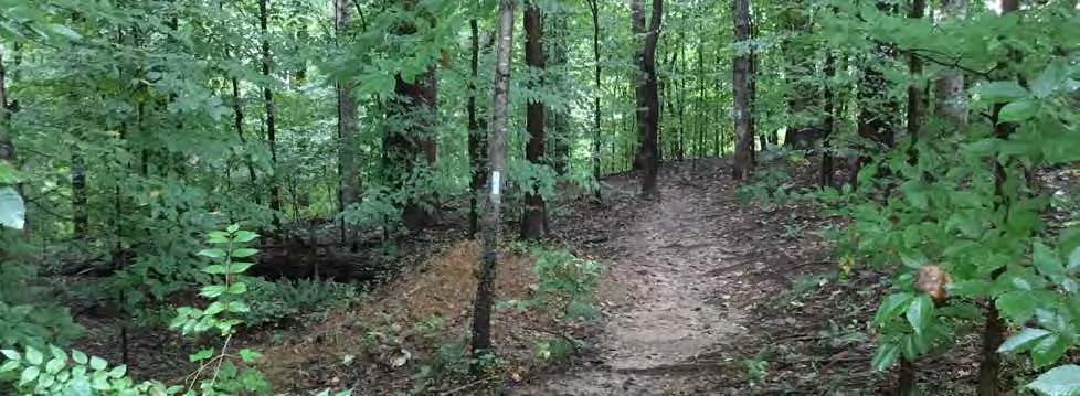
What Pedestrian/Bicycle Considerations Are in Build Alternatives?
-
Existing sidewalks, shared-use paths, bikeable shoulders, and bikeways impacted by proposed improvements will be replaced and upgraded.
-
The new American Legion Bridge will include new pedestrian and bicycle access to connect trails on both sides of the Potomac River.
-
New pedestrian and bicycle facilities to enhance connectivity and provide safe accommodation are being evaluated along the corridor in collaboration with local stakeholders.
American Legion Bridge
 *DEIS Ch. 2 & Appendix B
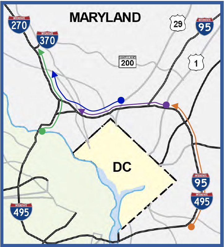
Where are the Proposed Interchanges and Managed Lanes Access Locations?
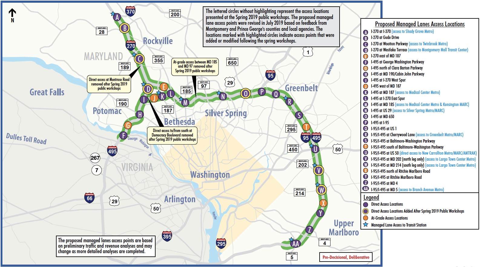 *DEIS Ch. 2 & Appendix B
What is Congestion Pricing?
-
Per FHWA*, congestion pricing is a way of harnessing the power of the market to reduce the waste associated with traffic congestion.
-
Congestion pricing enables the system to flow much more efficiently, allowing more vehicles and people to move through the same physical space.
-
Toll rates vary based on predicted (time of day) or dynamically measured congestion to ensure a specified travel speed.
* https://ops.fhwa.dot.gov/congestionpricing/
How Does Dynamic Pricing Work?
-
Maryland Transportation Authority (MDTA) Board will establish a public hearing process with a public review for the toll rate range for the facility.
-
Toll Rates are adjusted in response to real-time conditions, such as:
-
Travel speeds
-
Traffic density
-
Traffic volumes
-
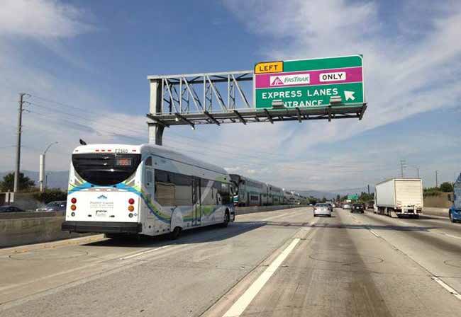
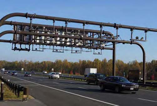
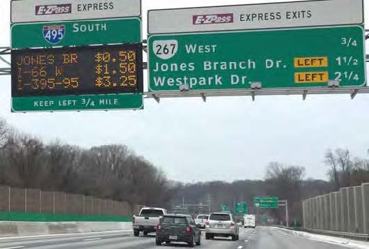
How Will the Managed Toll Lanes Work?
-
The tolls would be collected electronically at highway speeds, with no toll plazas or toll booths.
-
Toll rates would be adjusted dynamically within the approved toll rate range and could change in response to real-time changes in traffic conditions every 5 to 15 minutes to manage traffic flow and maintain a minimum average operating speed of 45 mph.
How Will the Toll Rates Be Set?
-
Toll rate ranges will be set as required by the Code of Maryland Regulations (COMAR 11.07.05, Public Notice of Toll Schedule Revisions).
-
Toll rates will be developed to manage traffic flow.
-
Toll range will include upper limit on toll rate per mile.
-
Public hearings for the toll rate range will be held in each county in which a toll is proposed to be implemented.
-
Public will have minimum 60-day comment period, anticipated for 2021.
-
What Will the Toll Rates Be?
-
DEIS does not recommend final proposed toll rate ranges; however, potential toll rates were estimated to meet the goals of the project and to determine if the Build Alternatives would be financially viable.
-
For planning purposes only, the estimated opening year (2025) average weekday toll rates per mile (in 2020 $) for all time periods for passenger cars using an E-ZPass transponder were:
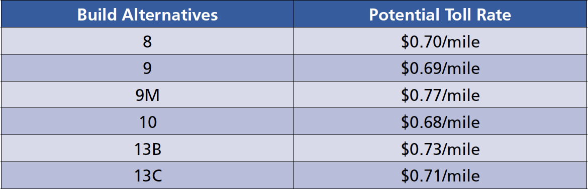 *DEIS Ch. 2 & Appendix B
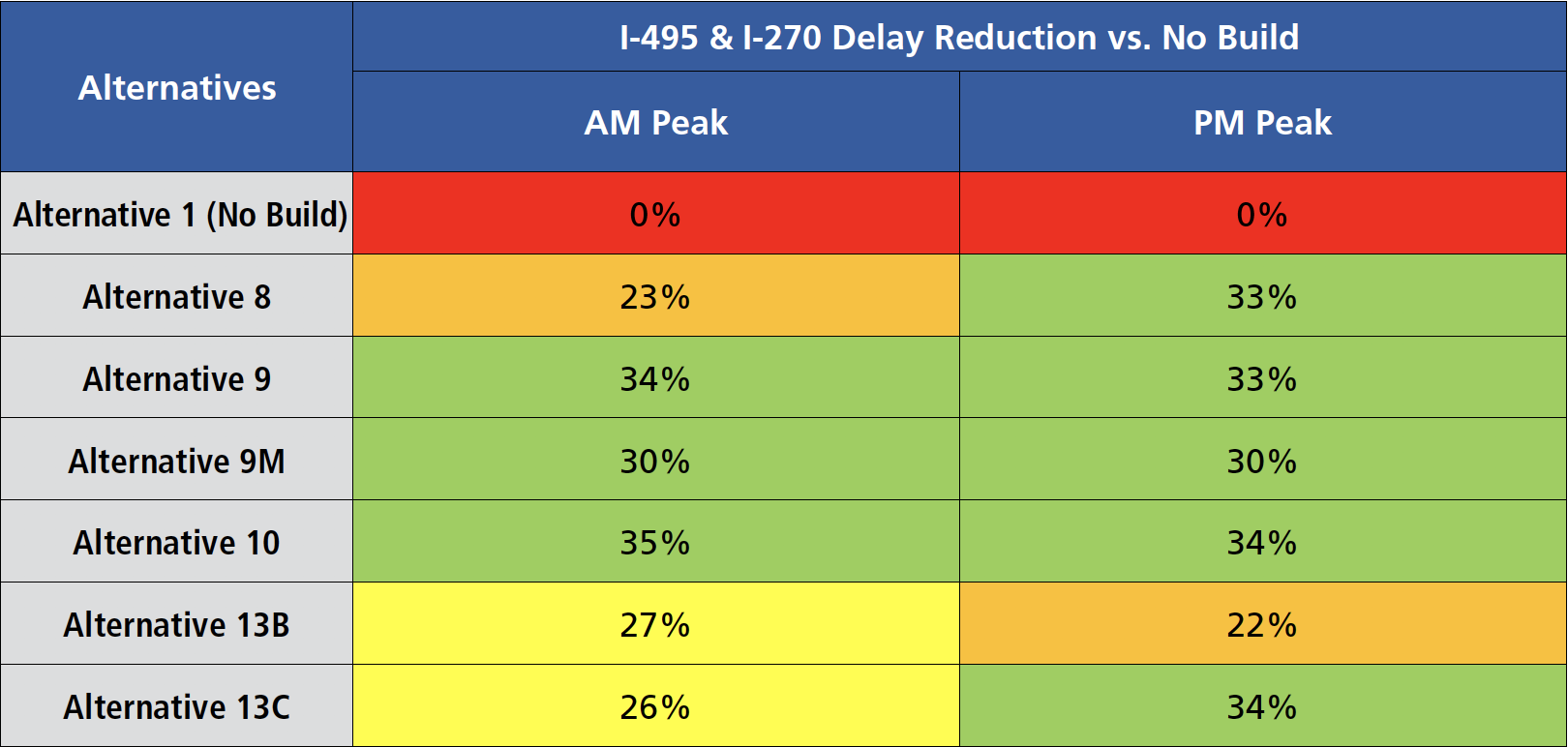
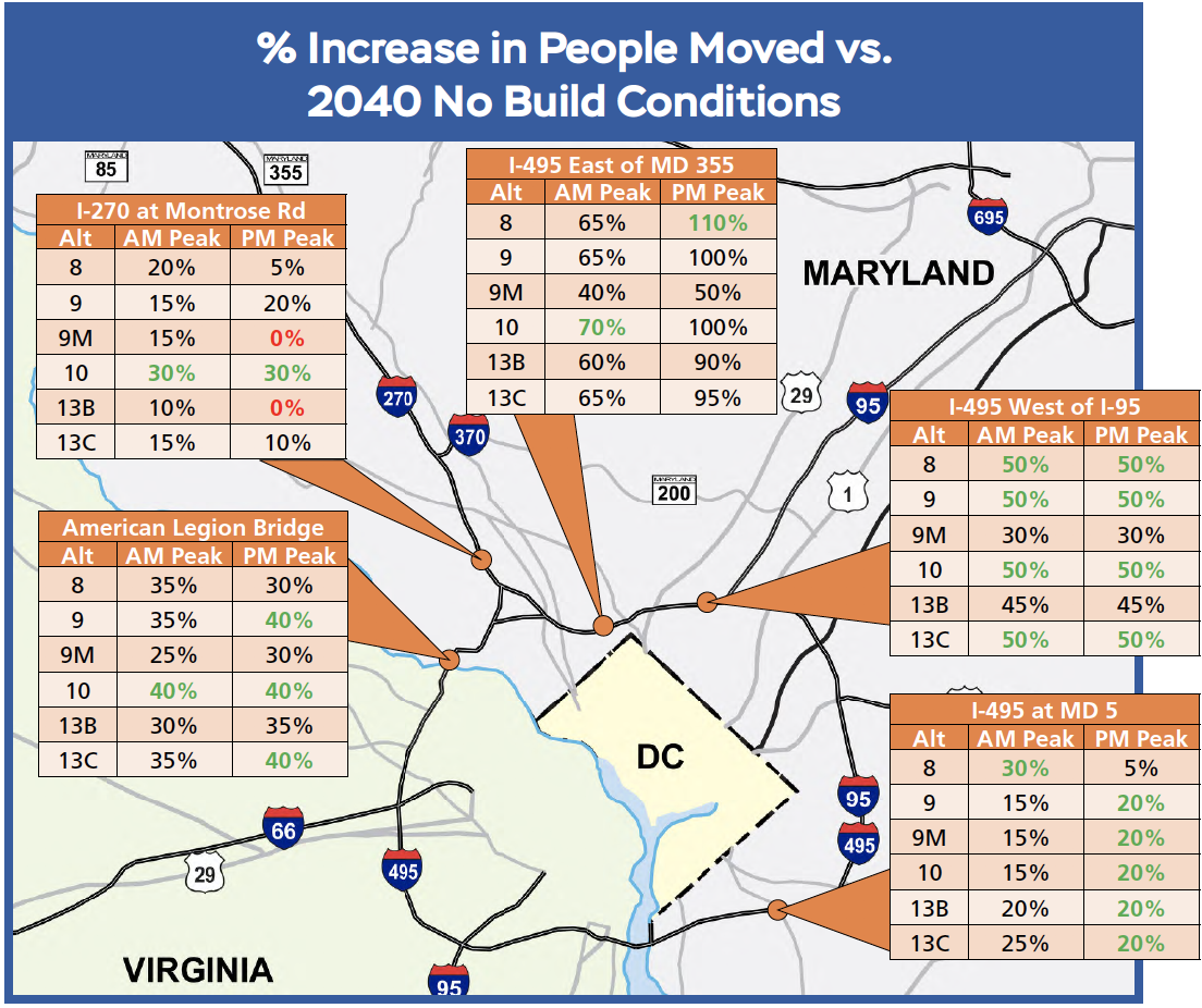
How Much Would the Alternatives Reduce Congestion and Delay?
-
-
Average delay per vehicle quantifies the amount of time motorists are delayed in traffic congestion on the highways within the study area.
-
All Build Alternatives are projected to reduce delay by 20% or more compared to the No Build condition, as shown below.
-
|
Legend
|
 |
- By serving more traffic on I-495 and I-270, each of the Build Alternatives are projected to reduce demand on the surrounding local roadway system, resulting in delay savings for local travelers, as shown below.
|
Legend
|
 |
How Will Traffic Operations Move People Through the Study Corridors?
- “Person-throughput” quantifies the efficiency of the roadway network in getting people to their destinations.
- Equals the number of people that pass by a given point on the roadway in a set amount of time.
- Accounts for high-occupancy vehicles and buses.
- Higher numbers are better.
- Benefits of high “person-throughput” on the highway:
- More efficient use of the roadway.
- Reduced peak spreading (i.e. less congestion in the off-peak hours).
- Reduced burden on the surrounding local roadway network (less cut-through traffic).
|
XX% Highest increase in “person-throughput” per location XX% No Benefit compared to 2040 No Build |
|
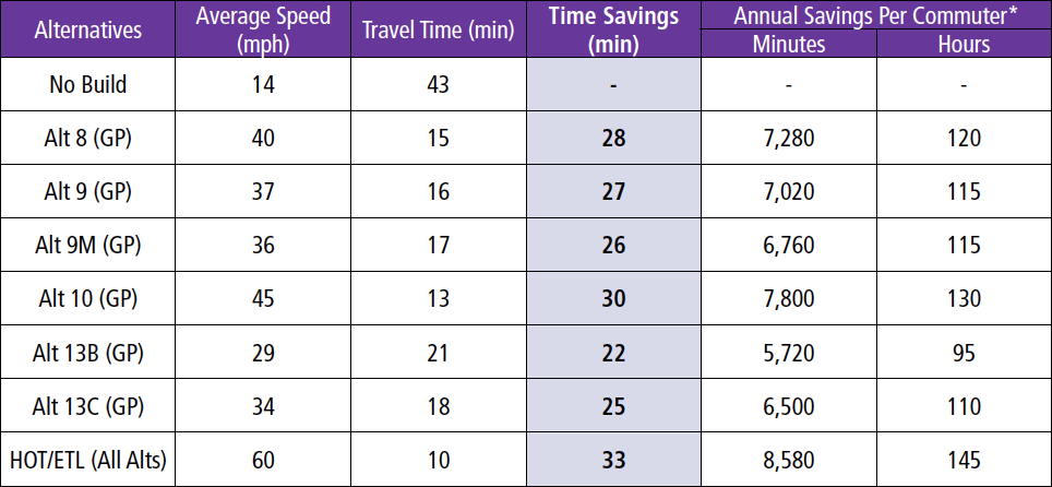
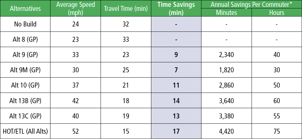
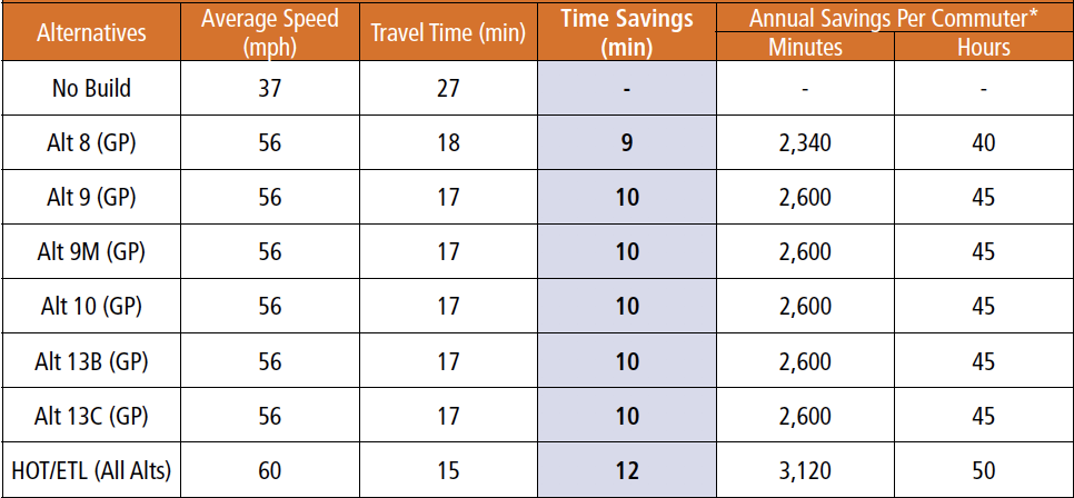
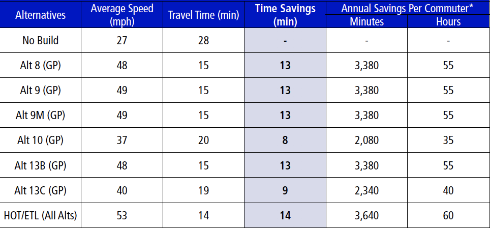
How Will the Build Alternatives Improve Travel Time?
HOT/ETLs would offer RELIABLE free-flow travel at or above 45 mph.
-
Average travel speeds (mph) and travel time (minutes) in the general purpose (GP) lanes for each Alternative are shown for four common weekday commute trip pairs in 2040. Data for managed lanes (HOT/ETL) are common to all Build Alternatives.
-
Annual savings per commuter quantifies the time savings per person compared to the No Build condition, assuming 260 commuting days in a year.
|
Commute from College Park to Bethesda (AM Peak Period) |
|
What Environmental Resources Were Analyzed?
The DEIS and Supporting Technical Reports
The DEIS presents the environmental resources identified along the study corridors, the anticipated effects to the resources, and measures to avoid, minimize, and mitigate unavoidable effects to those resources. The environmental resources and topics analyzed were:
-
Land Use and Zoning
-
Demographics
-
Communities and Community Facilities
-
Parks and Recreational Facilities
-
Property Acquisitions and Relocations
-
Visual and Aesthetic Resources
-
Historic Architecture and Archaeological Resources
-
Air Quality
-
Noise
-
Hazardous Materials
-
Topography, Geology and Soils
-
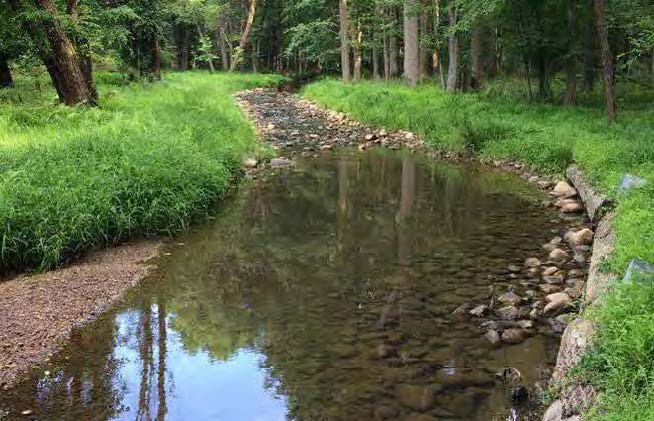
Waters of the US and Waters of the State, including Wetlands
-
Watersheds and Surface Water Quality
-
Groundwater Hydrology
-
Floodplains
-
Vegetation and Terrestrial Habitat
-
Terrestrial Wildlife
-
Aquatic Biota
-
Rare, Threatened and Endangered Species
-
Unique and Sensitive Areas
-
Environmental Justice
-
Indirect and Cumulative Effects
-
Consequences of Construction
-
Commitment of Resources
Comparison of the No Build and Build Alternatives
| Resource | Alternative 1 No Build | 1Alternative 5 | Alternative 8 | Alternative 9 | Alternative 9M | Alternative 10 | Alternative 13B | Alternative 13C | |
| Environmental: | Total Potential Impacts to Section 4(f) Properties including park and historic properties (acres) | 0 | 141.7 | 146.8 | 146.8 | 144.7 | 149.0 | 145.5 | 146.7 |
| Number of Historic Properties with Adverse Effect [Adverse effect cannot be determinded²] | 0 | 13[7] | 13[7] | 13[7] | 13[7] | 13[7] | 13[7] | 13[7] | |
| 100-Year Floodplain (acres) | 0 | 114.3 | 119.5 | 119.5 | 116.5 | 120.0 | 119.5 | 119.9 | |
| Unique and Sensitive Areas (acres) | 0 | 395.3 | 408.2 | 408.2 | 401.8 | 410.8 | 406.7 | 408.6 | |
| Forest canopy (acres) | 0 | 1,433.8 | 1,497.4 | 1497.4 | 1,477.2 | 1,514.5 | 1,488.8 | 1,503.2 | |
| Wetlands of Special State Concern | 0 | 0 | 0 | 0 | 0 | 0 | 0 | 0 | |
| Wetlands Field-Reviewed (acres) | 0 | 15.4 | 16.3 | 16.3 | 16.1 | 16.5 | 16.3 | 16.5 | |
| Wetland 25-foot buffer (acres) | 0 | 51.2 | 53.1 | 53.1 | 52.7 | 53.6 | 53.1 | 53.5 | |
| Waters of the US (linear feet) | 0 | 153,702 | 155,922 | 155,922 | 155,229 | 156,984 | 155,822 | 156,632 | |
| Tier II Catchments (acres) | 0 | 55.2 | 55.3 | 55.3 | 55.3 | 55.3 | 55.3 | 55.3 | |
| Noise Receptors Impacted | 0 | 3,661 | 4,470 | 4,470 | 4,249 | 4,581 | 4,411 | 4,461 | |
| Traffic | System-wide Delay Savings vs. No Build (AM/PM) | 0 | 20%/22% | 23%/33% | 34%/33% | 30%/30% | 35%/34% | 27%/22% | 26%/34% |
| Engineering | Total Right-of-way Required(acres) | 0 | 284.9 | 323.5 | 323.5 | 313.4 | 337.3 | 318.9 | 329.3 |
| Number of Properties Directly Affected | 0 | 1,240 | 1,475 | 1,475 | 1,392 | 1,518 | 1,447 | 1,479 | |
| Number of Residential Relocations | 0 | 25 | 34 | 34 | 25 | 34 | 34 | 34 | |
| Number of Business Relocations | 0 | 4 | 4 | 4 | 4 | 4 | 4 | 4 | |
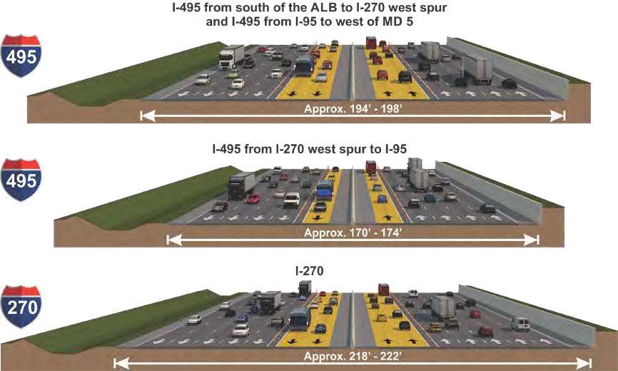
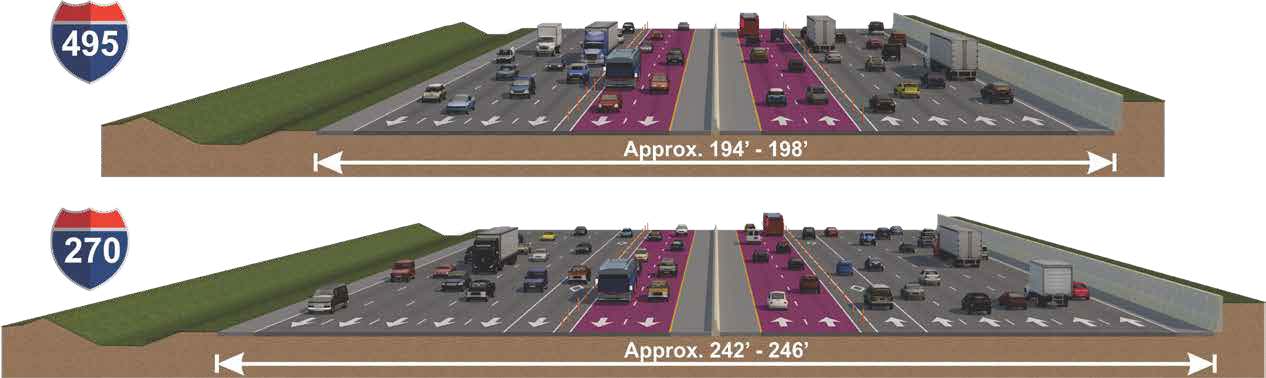
| Width of Pavement on I-495 (feet) | 194–198 | 170–174 | 194–198 | 194–198 | 170-198 | 194–198 | 194–198 | 194–198 | |
| Width of Pavement on I-270 (feet) | 228–256 | 194–198 | 218–222 | 218–222 | 218-222 | 242–248 | 202–206 | 226–230 | |
| Capital Cost Range [Construction & ROW] (billions) | N/A | $7.8– $8.5 | $8.7 – $9.6 | $8.7 – $9.6 | $8.5- $9.4 | $9.0 – $10.0 | $8.7 - $9.6 | $8.8 - $9.7 |
- Preliminary impacts represented above assume total impacts; permanent and temporary impacts will be distinguished in the FEIS.
- The right-of-way is based on State records research and filled in with county right-of-way, as necessary. With the Section 4(f) properties, some boundaries vary based on the presence of easements and differences in the size and location of historic and park boundaries.
- Noise receptors are noise-sensitive land uses which include residences, schools, places of worship, and parks, among other uses. Note that these numbers include receptors that do not have an existing noise wall as well as receptors that have an existing noise wall which is expected to be replaced.
- Efforts to avoid and minimize impacts have occurred throughout the planning process and will continue during the final design phase.
What Avoidance and Minimization Opportunities Have Been Considered for Effects to Environmental Resources?
- At this stage in the NEPA Study, opportunities to avoid and minimize impacts to the following resources have been coordinated with the regulatory and resource agencies and have been incorporated into the Build Alternatives:
- parklands
- wetlands
- wetland buffers
- waterways
- forests
- FEMA 100-year floodplains
-
Impacts were avoided or minimized to the greatest extent practicable at this stage of the Study, and avoidance and minimization techniques were further advanced in some areas of sensitive or recreationally valuable resources.
-
The effort to avoid, minimize and mitigate unavoidable impacts will continue through ongoing and future coordination with the applicable regulatory and resource agencies and be documented in the FEIS.
Examples of Results of Minimization Efforts
- Rock Creek: reduction in parkland impacts of approximately 10 acres and reduction in stream impacts by 3,287 linear feet
- Thomas Branch: reduction in stream impacts by 592 linear feet
- Paint Branch Mainstem: reduction in stream impacts by 2,393 linear feet
|
|
|
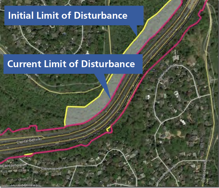
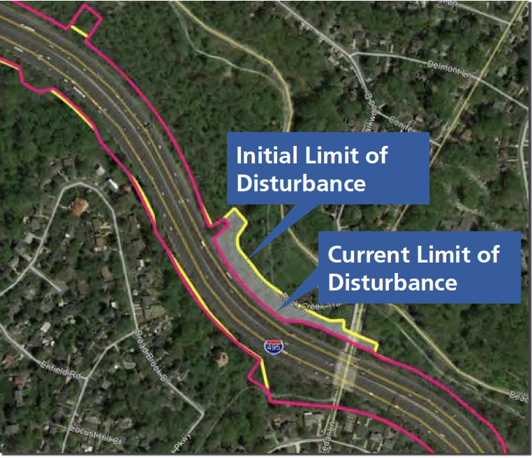
- Initial LOD
- Current LOD
What Are the Results of the Air Quality Analysis?
- Study area is in attainment (meaning, the area has monitored air quality that meets the National Ambient Air Quality Standard) for Carbon Monoxide (CO) and Particulate Matter and non-attainment for 2015 Ozone standard.
- The Study is currently included in the National Capital Region Transportation Planning Board FY 2019 – 2024 Transportation improvement program (TIP) and the Visualize 2045 Long Range Plan (LRTP) and the accompanying Air Quality Conformity Analysis.
- The estimated emissions from on road travel in the TIP and LRTP adhere to the motor vehicle emissions budgets for ozone pollutants and therefore demonstrate conformity with the State Implementation Plan.
- Quantitative CO, Mobile Source Air Toxics (MSATs) and greenhouse gas (GHG) analysis completed.
- Worst-case CO concentrations for all Build Alternatives remain well below the CO National Ambient Air Quality Standards (NAAQS) at all receptor locations for each interchange and intersection location analyzed.
- MSATs emissions expected to remain the same or slightly decrease for all Build Alternatives when compared to the No Build condition for 2040.
- GHG emissions expected to increase slightly for all Build Alternatives when compared to the No Build condition for 2040, but decrease compared to existing conditions.
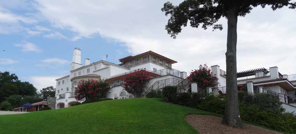
What Are the Section 4(f) Regulations?
- Section 4(f) of the US Department of Transportation (USDOT) Act of 1966, as amended (49 U.S.C. 303(c)) is a Federal law that protects publicly owned parks, recreation areas, wildlife and/or waterfowl refuges, or any public or private historic sites.
- Section 4(f) applies to all transportation projects that require funding or other approvals by the USDOT.
- Considerable efforts to avoid and minimize impacts to Section 4(f) properties have taken place throughout the planning process and will continue. However, all of the Build Alternatives would impact parks and historic sites along the study corridors.
FHWA cannot approve a transportation project that uses any Section 4(f) property, unless:
- There is no feasible and prudent avoidance alternative to the use and the action includes all possible planning to minimize harm to the property resulting from such use (23 CFR 774.3(a)); or
- The use of Section 4(f) property, including any measures to minimize harm (i.e., avoidance, minimization, mitigation, or enhancement measures) committed to by the applicant, will have a de minimis impact on the property (23 CFR 774.3(b).
A use of Section 4(f) property occurs:
- When land is permanently incorporated into a transportation facility.
- Where there is a temporary occupancy of land that is adverse in terms of the statue’s preservation purpose as determined by the criteria in 23 CFR 774.13(d); that is when one of the following criteria are not met.
- When there is a constructive use, which occurs only when a project does not incorporate land from a Section 4(f) property, and the proximity impacts of a project on adjacent or nearby property result in substantial impairment of the activities, features, or attributes that qualify a property for Section 4(f) protection.
 |
 |
 |
What Are the Results of the Draft Section 4(f) Evaluation?
Inventory of Section 4(f) Properties
111 Section 4(f) properties were inventoried within the corridor study boundary, including national parks, county and local parks, parkways, stream valley units of larger park facilities, and historic sites that are listed in or eligible for listing in the National Register of Historic Places.
- 43 properties would be avoided by the Build Alternatives
- 68 properties would experience an impact from the Build Alternatives
Properties Requiring Individual Evaluations
22 of the 68 properties would experience an impact qualifying as a Section 4(f) use resulting in an individual evaluation.
- Considers if there is a feasible and prudent alternative that completely avoids the use of all Section 4(f) properties
- Includes all possible planning to minimize harm to Section 4(f) properties
- Includes extensive agency coordination and public involvement
Properties with De Minimis Impacts
36 of the 68 properties would experience an impact so minor as to not adversely affect the activities, features, or attributes that qualify the property for protection under Section 4(f).
- De minimis impact determination does not require analysis to determine if avoidance alternatives are feasible and prudent, but consideration of avoidance, minimization, mitigation or enhancement measures should occur
The process to determine a de minimis impact is different for historic sites and parks.
- There are 13 historic sites that would experience a de minimis impact, including 4 properties that contribute to significance of an historic district. The State Historic Preservation Officer has concurred that the Study would have no adverse effect on each of these properties and provided written acknowledgment of FHWA’s intent to make a de minimis impact determination (in compliance with 23 CFR 774.5 (b)(1)).
- There are 27 publicly owned park properties that would experience a de minimis impact. FHWA intends to make a de minimis impact determination if the Officials with Jurisdiction over these parks concur that the Study, after measures to mitigate harm are employed, would not adversely affect the activities, features, or attributes that qualify the property for protection under Section 4(f); and in consideration of public comments in compliance with 23 CFR 774.5(b)(2)).
Exceptions
10 of the 68 properties, including 6 archaeological sites, would experience an impact from the Study but those impacts meet one or more exception to Section 4(f) use criteria (23 CFR 774.13).
*DEIS Ch. 5 & Appendix FPotential Mitigation
-
Publicly Owned Parks: Discussions with Officials with Jurisdiction over publicly owned park resources are ongoing to determine meaningful mitigation for impacts. Possible mitigation may include:
-
Replacement with lands of at least comparable value, and of reasonably equivalent usefulness and location.
-
Replacement of facilities impacted by the proposed improvements, including sidewalks, paths, benches, lights, trees, fields, courts, stormwater facilities, parking lots, trails, swales, buildings, and other facilities.
-
Relocation of recreational facilities outside of environmentally compromised areas (i.e., floodplains).
-
Restoration and landscaping of disturbed areas.
-
- Historic Sites: Discussions with Section 106 Consulting Parties is ongoing. All mitigation for impacts to historic properties will be covered in a Section 106 Programmatic Agreement.
 |
 |
What Does the Section 106 Process Include?
- Section 106 of the National Historic Preservation Act requires consideration of historic properties (including archaeology and historic architecture) in Federal projects, and avoiding, minimizing, or providing mitigation for adversely affected resources.
- Historic properties are those generally more than 50 years of age and that meet the National Register of Historic Places Eligibility Criteria.
What Are the Results of the Draft Section 106 Evaluation?
- MDOT SHA has evaluated more than 300 properties within the study corridor (see http://bit.ly/495-270-DOE). Thirteen properties may experience adverse effects and several properties require additional evaluation to assess effects as the design is developed further.
- Section 106 consultation is ongoing and will be completed via a Programmatic Agreement with consulting parties that stipulates mitigation and additional evaluation and treatment of historic properties.
 |
 |
 |
What Is Title VI?
Title VI, 42 U.S.C.,* Section 2000d et seq., was enacted as part of the Civil Rights Act of 1964. Title VI-related statutes and regulations provide that no person shall on the ground of race, color, national origin, sex, English proficiency, or disabilities be excluded from participation in, be denied the benefits of, or be subjected to discrimination under any program or activity.
*United States CodeWhy Is Title VI Important?
-
Title VI ensures that public services, including transportation, are provided in an equitable and nondiscriminatory manner.
-
Title VI provides opportunities for public participation in decision-making without regard to race, color, or national origin, including populations with Limited English Proficiency (LEP).
Filing a Complaint / Seeking Assistance
Should you need LEP assistance or if you believe MDOT SHA is not meeting the expectations of Title VI, you may direct questions, concerns, or file a complaint with:
Shabnam Izadi, Title VI Manager
MDOT State Highway Administration
Office of Equal Opportunity
211 E. Madison Street, MS-LL3
Baltimore, MD 21201
Email | sizadi@mdot.maryland.gov
Phone | 410-545-0377
Fax | 410-208-5008
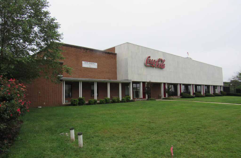
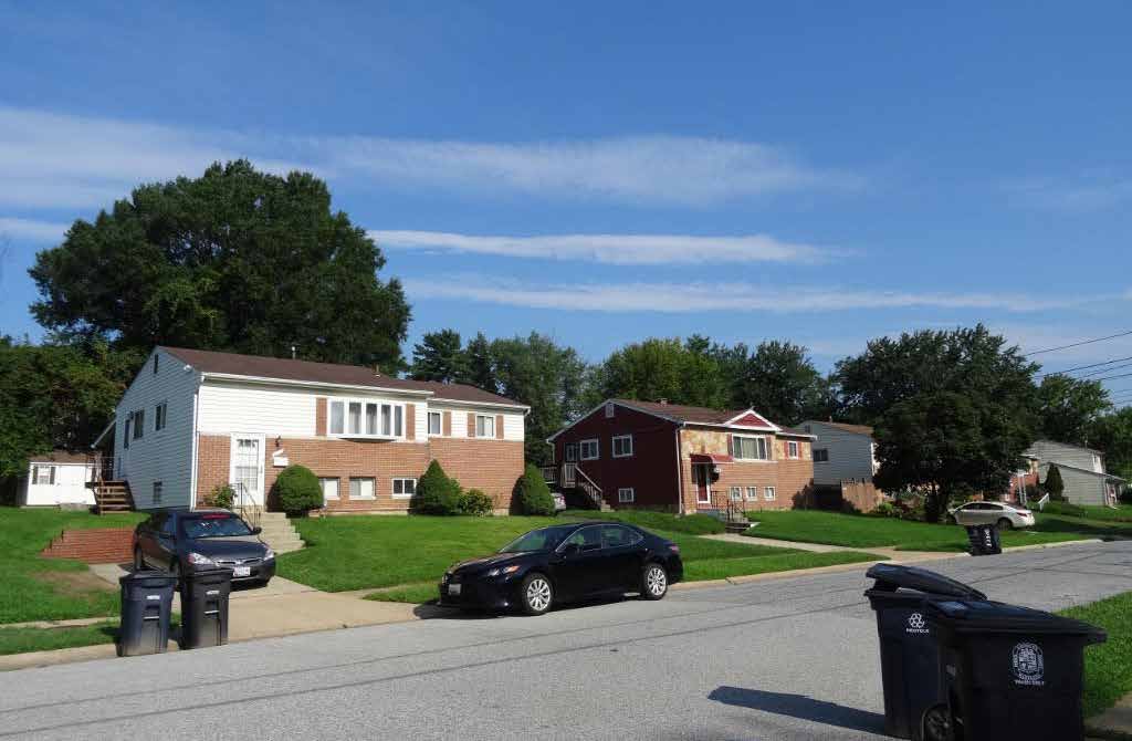
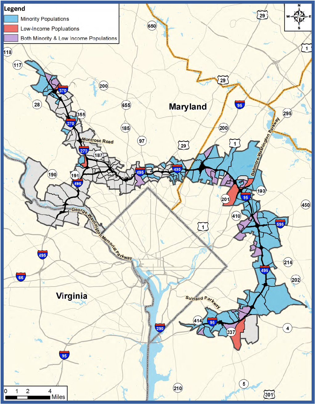
What Is Environmental Justice?
- Environmental Justice (EJ) means identifying and addressing disproportionately high and adverse effects of an action on minority (race or ethnicity) and/or low-income populations to achieve an equitable distribution of benefits and burdens.
- An EJ population is any readily identifiable group of minority (race or ethnicity) persons and/or low-income persons who live in geographic proximity and who will be similarly affected by a proposed project.
What Are the Effects to EJ Populations?
- Of the 199 Census block groups located along the study corridor, 111 are considered EJ populations.
- Effects to properties, noise, community facilities, parks, cultural resources, and natural resources within EJ populations would occur from the Build Alternatives.
- A final determination of whether disproportionately high and adverse effects would occur from the Preferred Alternative to EJ populations will be made in the FEIS. If disproportionately high and adverse effects are determined, MDOT SHA will evaluate options to avoid the adverse effects.
- If adverse impacts are unavoidable, mitigation and enhancement measures will be determined in close coordination with local communities.
 *DEIS Ch. 4 & Appendix E
Property Needs
What determines if my property is needed?- A variety of elements contribute to the need for additional property rights outside of MDOT SHA’s property. These elements include roadway construction, grading, clearing, landscaping, stormwater management, and noise barrier replacement/construction. Adjacent property rights would be needed in areas where MDOT SHA right-of-way is limited and where these elements cannot be located elsewhere.
- MDOT SHA complies with State and Federal laws to determine “just” compensation for impacts to your property.
- Just compensation is based on the fair market value of the property and includes all elements that may be appropriate in determining value.
- For full details on the acquisition process, please refer to the MDOT SHA Your Land and Your Highways: Your Rights and Benefits Guide.
-
MDOT SHA will advise you well in advance of actual negotiations. A letter will be mailed to you explaining that your property will be needed.
-
MDOT SHA will offer fair market value of your property, which will include just compensation for the property needed. Relocation assistance is a separate benefit that is provided, if eligible.
-
MDOT SHA can only provide compensation as part of the property acquisition process. However, we will work with you to address concerns related to any possible impacts on your property.
Reduction of Potential Property Needs
Have property needs been reduced?-
MDOT SHA has attempted to stay within existing ROW to the extent possible to avoid and/or minimize potential property needs.
-
Design and engineering options were analyzed to reduce the potential impacts by reducing grass and grading areas, adding retaining walls, modifying interchange ramp designs, adjusting direct access locations, shifting the centerline alignment, and locating stormwater facilities underground.
-
MDOT SHA has identified reasonable measures to reduce potential property needs as part of the preliminary design for NEPA. As this process moves forward, MDOT SHA is committed to identifying approaches that could further reduce potential property needs or mitigate any impacts to property.
-
More importantly, MDOT SHA will engage and incentivize the private sector through innovation to reduce property needs.
What Happens If My Property Is Directly Impacted?
Timeline of the Acquisition Process
Fall 2020 to Winter 2021-
Further avoidance & minimization to reduce needs will be evaluated and prioritized including incentivizing the private sector through innovation
-
Complete National Environmental Policy Act (NEPA) Study
- Identification - During final design, MDOT SHA determines if property is needed to construct the project (No earlier than late 2021)
- Formal Notification - Property owner will receive a notification letter
- Pre-Acquisition - MDOT SHA determines the property rights that may be needed for the new improvement and the impacts on your remaining property
- Appraisal - A qualified real estate appraiser will appraise your property and MDOT SHA will set the just compensation to be offered
- Negotiations - A real property specialist will contact you to set up an appointment to discuss the acquisition and the offer
How Do We Study Noise Impacts?
As part of NEPA, MDOT SHA evaluates the need for noise mitigation when alternatives propose changes to the existing noise environment. The analysis follows MDOT SHA’s Highway Noise Policy approved by FHWA. This evaluation includes five requirements:
- Determine if a noise impact currently exists, or is projected to exist as a result of the alternatives
A property is considered impacted when the noise level is equal to or higher than 66 decibels, or when projected noise levels are anticipated to increase substantially (10 decibels) over existing noise levels.
- Determine if noise mitigation is feasible
This requires at least 70% of the impacted properties within a community to receive a 5-decibel reduction in noise if noise mitigation were constructed, and that the proposed abatement can be constructed.
- Determine if noise mitigation is reasonable - WE ARE HERE
This requires that a majority of the impacted owners and residents be in favor of the mitigation and that the area of a noise barrier per benefitted resident be equal to or less than the appropriate evaluation threshold (between 700 - 2,700 square feet, depending on the project scope). At least 3 or 50% of impacted properties must receive a 7-decibel reduction in noise.
- Final Design Re-Evaluation
Once the project enters the final design phase, the noise abatement will be re-evaluated for feasibility and reasonableness using detailed engineering and traffic data.
- Final Design Public Outreach
As part of the final design phase, MDOT SHA will continue to coordinate with communities throughout the study area to seek feedback on the proposed noise abatement.
What Is the Proposed Noise Mitigation?
| Noise Barrier System Mitigation | Number of NSAs |
| Existing Noise Barriers that would remain in place as currently constructed | 7 |
| Existing Noise Barriers that would be relocated | 42 |
| Existing Noise Barriers that would be reconstructed and extended | 20 |
| New Noise Barriers constructed | 23 |
| Noise Barriers not proposed for construction | 19* |
NSA: Noise-sensitive Area
* An additional 19 barriers were evaluated but are not proposed for construction because they do not meet MDOT SHA’s feasibility and/or reasonableness criteria.
-
The findings in this analysis are based on preliminary design information and will be evaluated as part of the final design phase.
-
Engineering changes reflected in final design could alter the conclusions reached in this analysis, which could change MDOT SHA’s recommendations.
-
A Final Design Noise Analysis will be performed for this Study based on detailed engineering information during the final design phase.
-
The views and opinions of all benefited property owners and residents will be solicited through public involvement and outreach activities during final design.
What is Being Considered for Virginia?
Abatement for the portion of the study area within Virginia is being evaluated in coordination with the Virginia Department of Transportation (VDOT) and in compliance with the VDOT Highway Traffic Noise Impact Analysis Guidance Manual. The results of this evaluation will be included in the FEIS.
*DEIS Ch. 4 & Appendix JWhat Is the Joint Permit Application (JPA) and Permitting Process?
- The United States Army Corps of Engineers (USACE) and the Maryland Department of the Environment (MDE) are soliciting comments from the public; Federal, State, and local agencies; Native American Tribes; and other interested parties on the impacts to wetlands, wetland buffers, waterways, and FEMA 100-year floodplains as part of the permitting process.
- Comments received will be:
-
-
Considered by the USACE and MDE to determine whether to issue, modify, condition or deny permits and authorizations for this Study;
-
Used to assess impacts on endangered species, essential fish habitat, historic resources, tribal resources, and civil works projects, water quality, and Maryland’s Coastal Zone;
-
Used in the preparation of an Environmental Impact Statement, pursuant to NEPA;
-
Part of the public record; and
-
Used to determine the overall public interest of this Study.
-
- State and Federal permits are required for unavoidable impacts to wetlands, wetland buffers, waterways, and the FEMA 100-year floodplains from the I-495 & I-270 Managed Lanes Study. The Federal permit decision for these impacts is required to be made within 90 days of the NEPA Record of Decision, per Executive Order 13807-One Federal Decision.
- Permits are required from:
-
-
USACE for impacts to Waters of the US;
-
MDE for the alteration of FEMA 100-year floodplains, wetlands, their buffers, and Waters of the State; and
-
Virginia Department of Environmental Quality (VDEQ) for impacts to wetlands and waterways in Virginia.
-
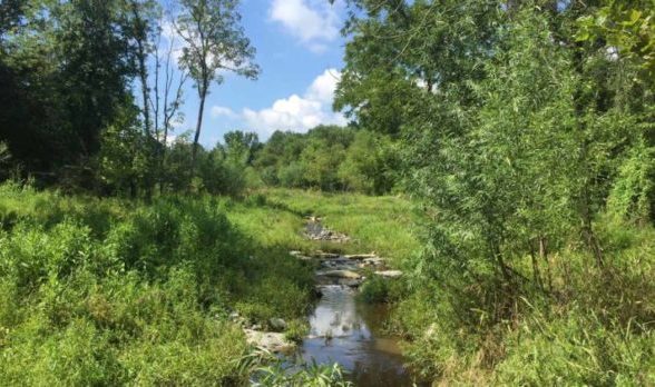
What Are the Impacts to Wetlands, Waterways, and Floodplains?
Unavoidable impacts to wetlands, wetland buffers, waterways, and the FEMA 100-year floodplains are summarized below. Impacts vary slightly between USACE and MDE based on their specific jurisdictional responsibilities.
| Alts 8 & 9 | Alt 9M | Alt 10 | Alt 13B | Alt 13C | ||||||
| MDE | USACE | MDE | USACE | MDE | USACE | MDE | USACE | MDE | USACE | |
| Waterways (linear feet) | 141,177 | 135,192 | 141,116 | 134,527 | 142,807 | 136,245 | 141,677 | 135,104 | 142,458 | 135,902 |
| Wetlands (acres) | 16.17 | 16.18 | 15.91 | 15.92 | 16.36 | 16.35 | 16.15 | 16.15 | 16.31 | 16.32 |
| Wetland Buffer (acres) | 52.99 | - | 52.50 | - | 53.48 | - | 52.93 | - | 53.35 | - |
| FEMA Floodplains (acres) | 119.5 | - | 116.5 | - | 120.0 | - | 119.5 | - | 119.9 | - |
| Palustrine Open Water (sq. ft.) | 61,134 | |||||||||
What Were the Avoidance and Minimization Efforts for Wetlands, Waterways, and Floodplains?
Efforts have been made throughout the Study to avoid and minimize impacts to wetlands and their buffers, waterways, and the FEMA 100-year floodplains to the greatest extent practicable. Avoidance and minimization of impacts to these resources is an integral part of the permitting process and is required by Federal and State regulations.
- Minimization of the constructed roadway footprint:
-
-
Elimination of the collector-distributor system on I-270
-
Utilization of closed drainage systems
-
Minimization of above ground stormwater management areas utilizing underground stormwater management practices
-
Use of engineered slopes and/or retaining walls
-
-
-
Minimization of interchange footprint, revised ramp design.
-
Roadway alignment shifts in key locations.
-
What Is the Draft Compensatory Mitigation Plan?
The Compensatory Mitigation Plan accompanies the JPA and identifies potential mitigation for impacts to wetlands and waterways. Mitigation will include stream restoration/enhancement and wetland creation/ enhancement focused on replacement of lost function in impacted watersheds within the study area in both Virginia and Maryland.
Virginia Mitigation
Virginia Wetland Mitigation Summary
| Watershed | Impact Type | MLS Mitigation Requirement (Ac) |
| Middle Potomac-Catoctin | Palustrine Forested | 0.1 |
Virginia Stream Mitigation Summary
| Watershed | MLS Mitigation Requirement (Lf) |
| Middle Potomac-Catoctin | 729 |
- Mitigation for impacts are calculated using Standard Ratios for Wetlands and the Unified Stream Method (USM) for streams.
- USM factors in functional loss associated with stream impacts and as a result, does not require mitigation for all stream impacts.
- Mitigation credits will be purchased from existing mitigation banks to meet mitigation requirements in Virginia.
Maryland Mitigation
Maryland Wetland Mitigation Summary
| Watershed | MLS Mitigation Requirement (Ac) | Proposed Mitigation Sites |
| Middle-Potomac-Anacostia-Occoquan | 18.53 | 4 |
| Middle Potomac-Catoctin | 2.51 | 4 |
| Patuxent | 9.05 | 1 |
| Total | 30.09 | 9 |
Maryland Stream Mitigation Summary
| Watershed | MLS Mitigation Requirement (Lf) | Proposed Mitigation Sites |
| Middle-Potomac-Anacostia-Occoquan | 20,045 | 7 |
| Middle Potomac-Catoctin | 15,134 | 5 |
| Patuxent | 5,317 | 2 |
| Total | 40,496 | 14 |
- Some stream impacts will not result in permanent loss of function and will not require mitigation.
-
Approximately 52,500 linear feet of stream impacts will not require mitigation.
-
Potential Wetland And Stream Mitigation Sites
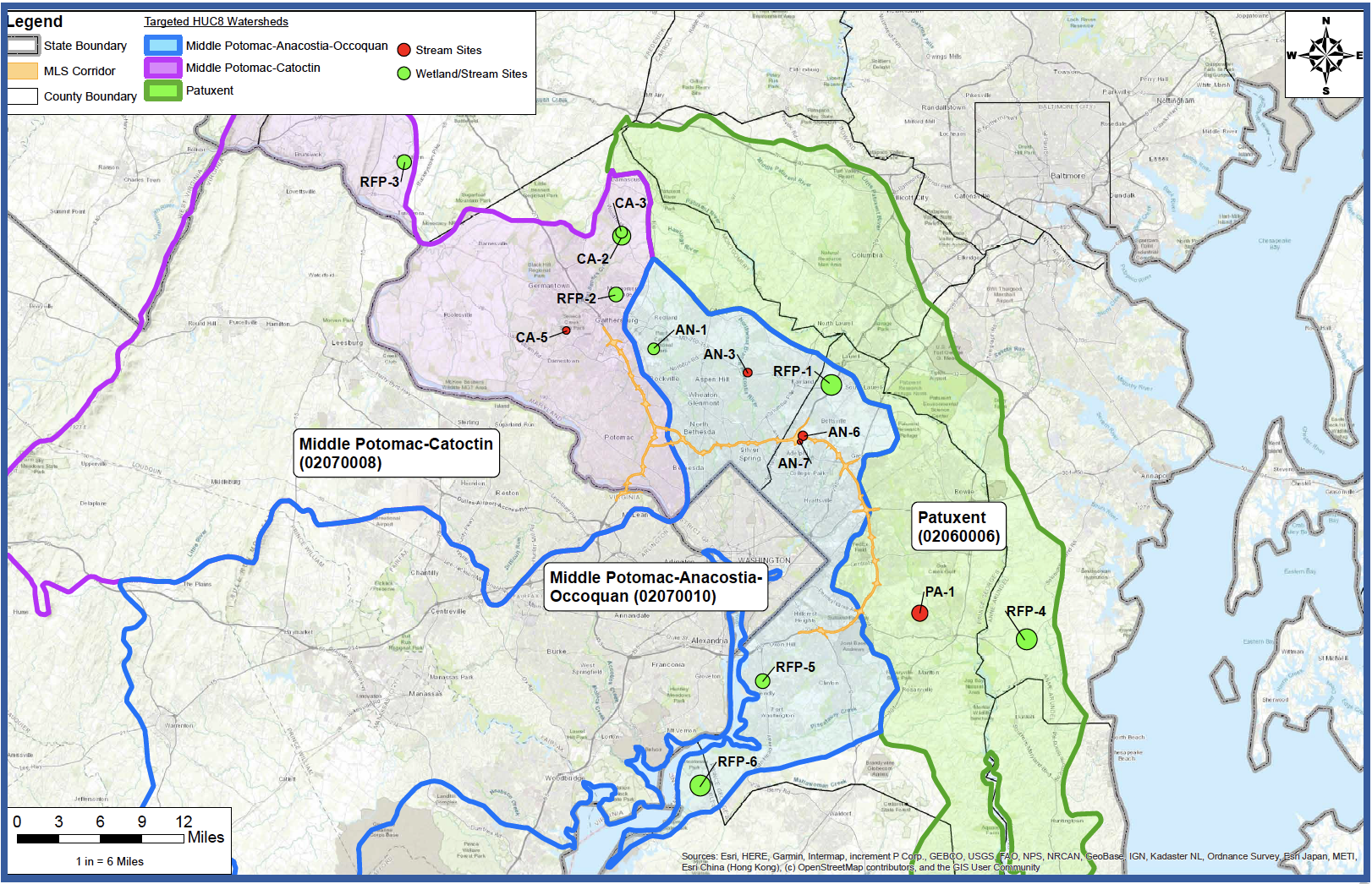 *DEIS Ch.4 & Appendices N,R
How Have We Engaged the Public & Stakeholders Since Spring 2018?
In-person Engagement
- 4 Public Workshops in April 2018 (370+)
- 4 Public Workshops in July 2018 (580+)
- 20+ Community Association Meetings (630+)
- 60+ Stakeholder Meetings (1,780+)
- 25+ Land Owner Meetings (160+)
- 8 Public Workshops in April/May 2019 (1,130+)
- 30+ Elected Official Briefings (350+)
- 14 Pop-up Events (1,840+)
Approximate number of attendees are shown in parentheses
Other Outreach Methods
- 7 targeted E-blasts delivering 13,000+ emails
- Washington Post and local newspapers reaching 1.5 million
- Geofencing and online ads 65,000+ impressions
- Targeted posts through MDOT SHA Facebook & Instagram
- Radio ads reaching 1.1 million across 10 stations
- Program website reaching 69,000+ users
How Have the Agencies Been Engaged With the Managed Lanes Study?
-
Interagency Working Group (IAWG) Meetings held monthly or as needed with approximately 35 Federal, State and local agencies.
-
Initiated in March 2018, coincident with NEPA Notice of Intent.
-
IAWG meetings held to provide an opportunity for full Federal, State and local agency engagement and participation in the study by developing, reviewing and discussing comments on study milestones, including purpose and need, alternatives, potential impacts and proposed avoidance, minimization and mitigation measures.
-
More than 100 individual Federal, State and local agency coordination meetings to discuss resources, impacts, and mitigation.
Cooperating Agencies
Federal:-
National Park Service
-
National Capital Planning Commission
-
US Army Corps of Engineers
-
US Environmental Protection Agency
-
Maryland Department of the Environment
-
Maryland Department of the Natural Resources
-
Virginia Department of Transportation
-
Maryland-National Capital Park and Planning Commission
Participating Agencies
Federal:-
Federal Transit Administration, US Fish & Wildlife Service (USFWS), Federal Railroad Administration (FRA), National Marine Fisheries Service, Joint Base Andrews, US Navy, US Postal Service, US Department of Agriculture-Beltsville Agricultural Research Center (USDA-BARC), US Coast Guard
-
Maryland Historical Trust (MHT), Maryland Department of Planning (MDP), Maryland Transit Administration (MDOT MTA), Maryland Transportation Authority (MDTA), Virginia Department of Historic Resources, Virginia Department of Conservation and Recreation
-
Montgomery County Department of Transportation, Prince Georges County Department of Public Works & Transportation (DPW&T)
What Are Ways to Comment on the Draft Environmental Impact Statement and the Joint Permit Application at the Hearing?
-
Oral testimony to panelists at in-person or virtual hearing
-
Oral testimony to court reporter at in-person hearing
-
Oral testimony via voicemail (855-432-1483) during in-person or virtual hearing times
-
Written comments in comment box at in-person hearing
What Are Other Ways to Comment on the Draft Environmental Impact Statement and the Joint Permit Application?
Other Ways to Comment on the DEIS
-
Comment Form on oplanesmd.com/DEIS/
-
Email at MLS-NEPA-P3@mdot.maryland.gov
-
Send a written letter about DEIS:
Lisa B. Choplin, Director
I-495 & I-270 P3 Office
Maryland Department of Transportation
State Highway Administration
707 North Calvert Street
Mail Stop P-601, Baltimore, MD 21202
Other Ways to Comment on the JPA
-
Email at john.j.dinne@usace.army.mil (USACE), MDE.SHAprojects@maryland.gov (MDE)
- Send a written letter about JPA:
|
USACE Baltimore District Attn: Mr. Jack Dinne 2 Hopkins Plaza Baltimore, MD 21201-2930 |
MDE Wetlands and Waterways Program Attn: Mr. Steve Hurt 1800 Washington Blvd., Suite 4300 Baltimore, MD 21230 |


